
Skip to content
VividMaps

  • Atlases
  • Map Posters
  • Scratch Maps
  • Globes
  • Videos
SubwayTransport
July 4, 2016 Alex

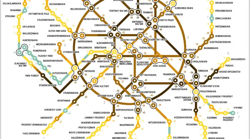
The tunnels depth scheme of the Moscow subway

Read more: The tunnels depth scheme of the Moscow subway →
Interactive mapsTransport
July 4, 2016 Alex

Closing the Metro Map: Madrid is closing Line 1 of its subway

23 stations of Sierra de Guadalupe Plaza de Castilla (“Line 1”), closed until 12 November. Line 1 is the second

Read more: Closing the Metro Map: Madrid is closing Line 1 of its subway →
Ethnic maps
July 4, 2016 Alex

Hispanic growth in Florida (percent growth by county 2010-2015)

Via miamiherald.com Related posts:  – U.S. Hispanic population, percent increase by county – U.S. Hispanic Population under 5 years of age

Read more: Hispanic growth in Florida (percent growth by county 2010-2015) →
ArtGoogleMapping Stereotypes
July 4, 2016 Alex

The power equipmenty most Googled by each state & province

What is the most popular power equipment of each state and province in US & Canada?

Read more: The power equipmenty most Googled by each state & province →
3D mapsAgricultureEconomic mapsEUInternetLawsMapping Stereotypes
July 4, 2016 Alex

% growth in real per capita GDP from 1995 to 2014

Read more: % growth in real per capita GDP from 1995 to 2014 →
Crime mapsMapping StereotypesSlider
July 3, 2016 Alex

What do South Koreans think about Asian countries

Read more: What do South Koreans think about Asian countries →
Historical MapsRivers
July 3, 2016 Alex

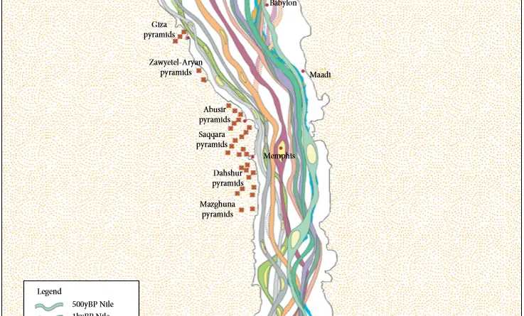
How Long is the Nile River?

The Nile river is the longest river in the world at 6,650 kilometers (4,135 miles). The Nile is longer than the distance from New York to London.

Read more: How Long is the Nile River? →
Old maps
July 3, 2016 Alex

A German plan for the partition of the Soviet Union (May 1941)

In the months before the German invasion of the Soviet Union the German leaders discussed many plans for the future

Read more: A German plan for the partition of the Soviet Union (May 1941) →
Old maps
July 3, 2016 Alex

Population Map of Australia (1921)

Read more: Population Map of Australia (1921) →
Economic mapsSliderWorld
July 3, 2016 Alex

Cost of Living Index normalized to U.S.

Related post: – Cost of renting normalized to U.S.

Read more: Cost of Living Index normalized to U.S. →
Mars with water
MarsSpace
July 3, 2016 Alex

How would Mars look like with water?

The two Martian polar ice caps seem to be made mostly of water. If only the south polar ice cap melted water cover Mars’s surface to a depth of 11 meters (36 feet).

Read more: How would Mars look like with water? →
Crime mapsInternetMapping StereotypesOld maps
July 3, 2016 Alex

Map of Africa (1839)

“Map of Africa Designed to Accompany Smith’s Geography for Schools.”

Read more: Map of Africa (1839) →
EUImmigration
July 3, 2016 Alex

Number of citizens living outside their home country

Via metrocosm.com Related post:  – Number of UK citizens livibn in other EU states

Read more: Number of citizens living outside their home country →
Page 268 of 521« First«...264265266267268269270271272...»Last »

Trending now

  • World Map of the Most Uniquely Popular Word On Every County's Wikipedia Page
    The Most Uniquely Popular Word on Each Country’s Wikipedia Page MappedDec 1, 2022
  • Steel production in 1800 mapped
    220 Years of Steel Production, Mapped From 1800 to 2025Oct 18, 2026
  • Largest Ancestry in the United States
    Largest Ancestry by U.S. CountyMar 23, 2019

Related Products

  • Push pin maps
  • Globe drinks cabinets
  • Maps of the United States
  • Board games
  • Monopoly
  • Map-based strategy board games
  • History Board Games
  • Coloring Books
  • Handheld GPS
  • GPS Watches
  • GPS Trackers

Vivid Maps Tools

  • Convert Latitude/Longitude
  • Elevation Finder
  • Distance Calculator
  • Kilometers to Miles Distance & Length Converter
  • Weight Converter
  • Volume Converter
  • Daylight Comparison
  • Time Zone Converter
  • Antipodes Map
  • Find cities with a similar climate
  • Find cities with a similar climate (2050)
  • How hot cities could be in 2050
  • The U.S. Population Lines

Stay connected

Get the latest maps, insights and updates delivered to your inbox.

Unsubscribe anytime.

VividMaps

Maps that explain the world.

Beautiful, data-rich maps to help you understand our world — its people, places and connections.

Explore

World map World atlas Map posters Globes

Company

About Privacy Contact

Stay connected

Follow us for the latest maps, insights and updates.

Independent WebsiteVirusScanner trust report for vividmaps.com
© 2026 Vivid Maps. All rights reserved.
A more connected world