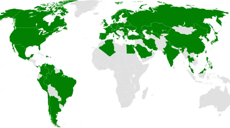
Skip to content
Vivid Maps Logo

Vivid Maps

Maps that explain the World


  • Atlases
  • Map Posters
  • Scratch Maps
  • Globes

Subway

Subway systems in the world
Subway Transport 

Countries that have subway systems

February 8, 2018February 8, 2018 Alex 0 Comments Maps of world

The largest metro systems in the World: Tokyo (Japan) City’s population density: 16,121.8/sq.mi System Length: 206 miles Number of annual

Read more
Cities Mapping Stereotypes Metro maps Subway Transport 

Subway Maps compared to its real geography

May 20, 2017December 27, 2017 Alex 0 Comments

London Reddit user: Pham_Trinli New York City Reddit user: playhouse_animation Washington Boston Atlanta Reddit user: D3signAllTheThings Toronto Source: mapto.ca Montreal

Read more
Subway Transport 

NYC Subway: Map vs. Geographic Distances

May 20, 2017June 9, 2018 Alex 0 Comments New York, United States

Reddit user: playhouse_animation NYC subway lines from an Ariel picture   Related posts: – New York City subway track map

Read more
Subway Transport 

The History of the Underground

May 18, 2017December 27, 2017 Alex 0 Comments London

Source: citylines.co

Read more
Mapping Subway Transport Voronoi maps 

London Tube Map with Voronoi, showing closest station for every location in the city

May 14, 2017December 27, 2017 Alex 0 Comments London, UK

Source: bl.ocks.org Related posts: – Key bus routes in central London (with top tourist attractions) – London Traffic Counts Map –

Read more
Internet Subway Transport 

New York City subway track map

May 13, 2017June 9, 2018 Alex 0 Comments New York, United States

Source: www.vanshnookenraggen.com   Related posts: – New York’s Subway Deserts – New York City Subway stations renamed after their most

Read more
Historical Maps Metro maps Subway Video Vivid maps 

Primary source of food for the various Native North American tribes in the pre-Columbian era (agriculture, hunting, fishing, hunting-gathering)

October 3, 2016 Alex 0 Comments North America

Related posts: – Historical Map of Native American Tribes in the Continental United States – The native tribes of North

Read more
Laws Mapping Stereotypes Subway Video World 

Atlas of long distance relationship

October 2, 2016 Alex 0 Comments Maps of world

Interesting facts: – The longest clocked in at 44 years, but there were five relationships reported over 30 years and at

Read more
Subway Transport Voronoi maps 

The subway of New York City as a Voronoi tessellation

September 30, 2016 Alex 0 Comments New York, United States

Related posts: – New York’s Subway Deserts – New York City boroughs journey to work-driving ca alone vs. walk/public transportation – New York

Read more
Slider Sociology Subway Video World 

Map of geo-social division

September 29, 2016 Alex 0 Comments Japan, Maps of world
Read more
Page 1 of 212»

Advertisement

Find Us On Facebook

Vivid Maps

Trending now

  • Sea leverl rise
    Climate Change, News, Oceans
  • The maps below created by Reddit user: symmy546 is visualizing the bombing attacks campaign of the western allies in World War 2. Every point describes a bombardment attack led by the allies. The points are colored according to the country
    Historical Maps, Wars
  • Map of the Panama Chanel
    Oceans, Transity Maps
  • Animated maps, Demography, News, Vivid maps
  • Interactive maps, Political maps, Travel

Advertisement


Push pin maps · Globe drinks cabinets · Board games · Monopoly · Map-based strategy board games

Vivid Maps Tools

– Find cities with a similar climate
– Find cities with a similar climate (2050)
– How hot cities could be in 2050
– The U.S. Population Lines
– Convert Latitude/Longitude

– About

Copyright © 2021 Vivid Maps. All rights reserved.