Skip to content
Vivid Maps Logo

  • Atlases
  • Map Posters
  • Scratch Maps
  • Globes
  • Videos
Ethnic mapsHumanityLaws
September 28, 2016 Alex

Bar operating hours across U.S.

Read More
BusinessFoodGermanyHistorical MapsLanguages
September 28, 2016 Alex

German speaking areas in Europe before & after 1945

Read More
Interactive mapsMapping Health
September 28, 2016 Alex

Vaccine skeptics are everywhere

The data represented below come from a survey of nearly 66,000 people across 67 countries and regions. Study participants were

Read More
Cultural cartographyNatureSliderVideo
September 28, 2016 Alex

The Great Smoky Mountains national park species interactive map

Read More
Environment mapsInteractive mapsMapping StereotypesPollutionSliderWorld
September 28, 2016 Alex

Global ambient air pollution

WHO Guideline values (annual mean) PM2.5: 10 μg/m3 , PM10: 20 μg/m3 The boundaries and names shown and the designations

Read More
Animated mapsPopulation
September 28, 2016 Alex

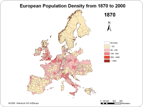
European population density (1870 – 2000)

Related post: – Projected change in European population between today and 2080

Read More
LawsMapping StereotypesRiversTransportVideo
September 26, 2016 Alex

Hourly traffic on the United States Interstate, visualized as a living circulatory system

Highway networks are often compared to the human circulatory system, an analogy that works on many levels. The hierarchical structure

Read More
DemographyInteractive maps
September 26, 2016 Alex

Percentage of live births outside marriage or civil partnership in Great Britain per local authority districts (2015)

United Kingdom average Rate: 47.9 % Highest: Knowsley (74.8%) Lowest: Harrow(20.3%)

Read More
BusinessFragile States IndexIndexesInternetPolitical mapsSlider
September 26, 2016 Alex

Where requests to censor tweets came from in 2016

1. Turkey (48%)2. Russia (31%) 3. France (9%)4. UK (3%)5. US (2%)6. Japan (1%) Via transparency.twitter.com

Read More
CartogramsNatureSize comparison mapsSlider
September 26, 2016 Alex

How far could you theoretically see from the top of Mount Everest?

How far could you theoretically see from the top of Mount Everest in a perfectly clear weather, with perfect vision

Read More
Page 299 of 675« First«...102030...297298299300301...310320330...»Last »

Trending now

  • The most used Emoji in every country
    The Most Used Emoji on Twitter in Every Country Mapped
  • The Price of Sex around the World Mapped

Related Products

Push pin maps · Globe drinks cabinets · Maps of the United States · Board games · Monopoly · Map-based strategy board games · History Board Games · Coloring Books · Handheld GPS · GPS Watches · GPS Trackers

Vivid Maps Tools

· Convert Latitude/Longitude
· Elevation Finder
· Distance Calculator
· Kilometers to Miles Converter
· Kilograms to Pounds Converter
· Liters to Gallons Converter
· Temperature Converter
· Find cities with a similar climate
· Find cities with a similar climate (2050)
· How hot cities could be in 2050
· The U.S. Population Lines

About
Privacy Policy

Copyright © 2025 Vivid Maps. All rights reserved.