Skip to content
Vivid Maps Logo

  • Atlases
  • Map Posters
  • Scratch Maps
  • Globes
  • Videos
BusinessEconomic mapsMapping StereotypesWorld
August 5, 2016 Alex

World Currencies Map

Read More
EducationSliderVivid maps
August 4, 2016 Alex

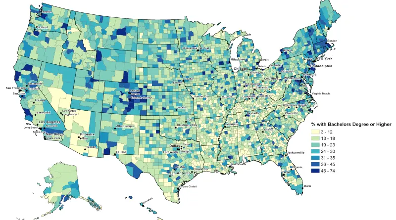
Most & Least Educated Counties in the U.S.

The most educated counties 1. Falls Church city (Virginia) – 74.4 2. Arlington County (Virginia) – 71.7 3. Los Alamos

Read More
AgricultureEconomic mapsMapping StereotypesPolitical maps
August 4, 2016 Alex

Tracking the 2016 Presidential Money Race

Where the money came from? Hillary Clinton (Campaign raised to date – $264.4M) Donald Trump (Campaign raised to date –

Read More
Economic mapsMapping Stereotypes
August 4, 2016 Alex

The relative value of $100: Which state offers the biggest bang for your buck?

The real value of $100 in each U.S. state. Numbers represent value of goods that $100 dollars can buy in

Read More
Ethnic mapsOld maps
August 4, 2016 Alex

Slave Population of the United States

U.S. Census maps from 1790-1861 list enslaved population percentages by county, topping 70% in many Mississippi River and South Carolina/Georgia coastal spots by 1860.

Read More
Economic mapsEUForecastsMap ProjectionsMapping Stereotypes
August 4, 2016 Alex

Map of EU regions by level of economic development (2014 – 2020)


Read More
Maps of World Religions
August 4, 2016 Alex

Top 10 highest and lowest church weekly attendance levels by US state

Read More
Economic mapsVivid maps
August 3, 2016 Alex

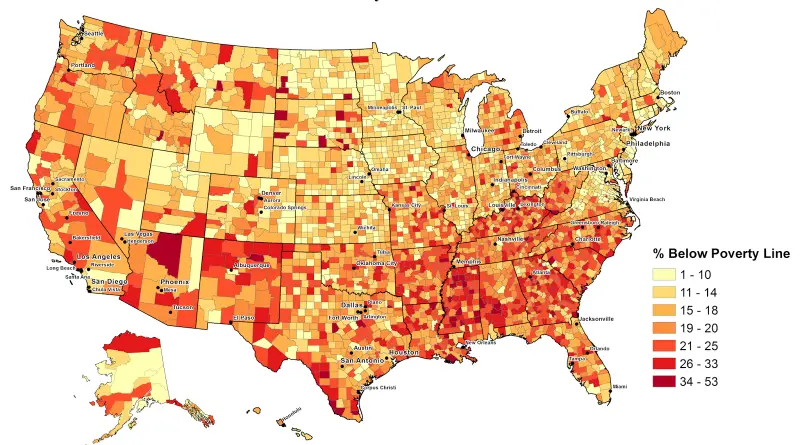
Poverty in the United States

% of people below the poverty line for each U.S. county. Top 10 poorest counties1. Shannon County (South Dakota) –

Read More
InfographicsSport
August 3, 2016 Alex

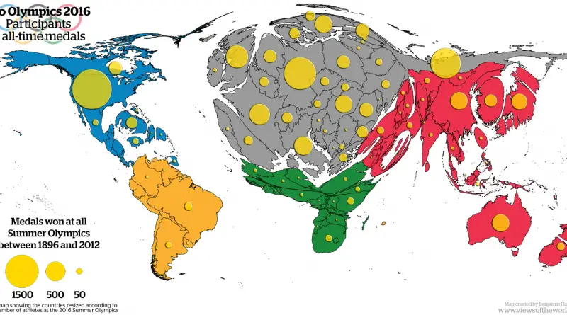
Rio Olympics 2016: Participants &All-Time Medals

Participants of the 2016 summer Olympics Total number of gold medals won at all summer Olympics Via viewsoftheworld.net & geographical.co.uk

Read More
Historical MapsInteractive mapsTransport
August 3, 2016 Alex

Historic maps of every Great Britain railway line that ever existed

The railroad system in Great Britain is the oldest in the world. The first public railway opened in 1825, which was followed by an era of fast growth. National Rail network controls most of the railroads in the country (15,811 kilometers or 9,824 miles).

Read More
Page 326 of 679« First«...102030...324325326327328...340350360...»Last »

Trending now

  • Decolonisation of Africa mapped
    Atlas of the colonization and decolonization of Africa
  • The largest territorial expanse of the Roman Empire
    The Roman Empire at its Territorial Height

Related Products

Push pin maps · Globe drinks cabinets · Maps of the United States · Board games · Monopoly · Map-based strategy board games · History Board Games · Coloring Books · Handheld GPS · GPS Watches · GPS Trackers

Vivid Maps Tools

· Convert Latitude/Longitude
· Elevation Finder
· Distance Calculator
· Kilometers to Miles Converter
· Kilograms to Pounds Converter
· Liters to Gallons Converter
· Temperature Converter
· Antipodes Map
· Find cities with a similar climate
· Find cities with a similar climate (2050)
· How hot cities could be in 2050
· The U.S. Population Lines

About
Privacy Policy

Copyright © 2026 Vivid Maps. All rights reserved.