Skip to content
VividMaps

  • Atlases
  • Map Posters
  • Scratch Maps
  • Globes
  • Videos
BusinessDemographyInteractive mapsMapping Stereotypes
March 11, 2016 Alex

The dot density map of women

Relates posts: – The racial dot map

Read more: The dot density map of women →

Animated mapsCitiesInteractive maps
March 11, 2016 Alex

Melbourne building heights

Relates posts: – Vancouver building heights – The Toronto height map  – Building heights in London

Read more: Melbourne building heights →
CitiesInteractive maps
March 11, 2016 Alex

Vancouver building heights

Relates posts: – The Toronto height map – Building heights in London

Read more: Vancouver building heights →
CitiesInteractive mapsReal estate
March 11, 2016 Alex

The Toronto height map

Source: http://jonathancritchley.ca/TOHeight_post.html Relates posts: – Building heights in London

Read more: The Toronto height map →
AgricultureWorld
March 11, 2016 Alex

Global grain consumption map

Read more: Global grain consumption map →
BusinessClimateInternetMapping StereotypesSize comparison maps
March 11, 2016 Alex

Oceania map of Koppen climate classification

Read more: Oceania map of Koppen climate classification →
AgricultureCrime mapsMapping Stereotypes
March 11, 2016 Alex

Inland limit for reliable production of sown crops and pastures

Read more: Inland limit for reliable production of sown crops and pastures →
InternetPolitical maps
March 10, 2016 Alex

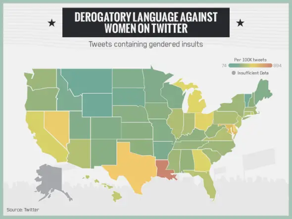
The States with the highest concentrations of racist, misogynist, and homophobic tweets

Louisiana is home to the people who tweet derogatory slurs with the highest frequency in the country, according to a

Read more: The States with the highest concentrations of racist, misogynist, and homophobic tweets →
Historical MapsMapping StereotypesWorld
March 10, 2016 Alex

Swedish empire at its largest extent

Read more: Swedish empire at its largest extent →
CartogramsClimate ChangeInternetVideo
March 10, 2016 Alex

The online World: Country code domain names by popularity

Did you know? – In the 1980s, the USA wanted the UK to use .gb domain names. However, many .uk

Read more: The online World: Country code domain names by popularity →
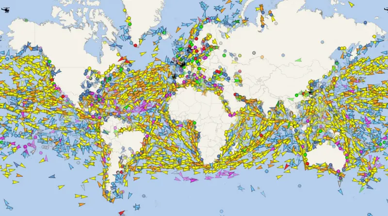
Maritime traffic density around the World
Interactive mapsTransport
March 10, 2016 Alex

All the ships in the World ocean

About 80% of the world trade by volume and over 70% of the global business by value are provided by vessels. The assumption is that dozens of thousands of vessels travel around the oceans and also rivers every day.

Read more: All the ships in the World ocean →
Global WarmingMapping Stereotypes
March 10, 2016 Alex

Yearly changes in sea level, in millimeters

Sea levels creep higher and higher Here’s where the water meets the road: Melting ice raises sea levels, and so

Read more: Yearly changes in sea level, in millimeters →
AgricultureArtLidarRivers
March 10, 2016 Alex

Willamette river channels

This lidar image of the Willamette River was originally the result of visual experimentation with color ramps and lidar elevation

Read more: Willamette river channels →
Page 328 of 521« First«...324325326327328329330331332...»Last »

Trending now

  • Steel production in 1800 mapped
    220 Years of Steel Production, Mapped From 1800 to 2025Oct 18, 2026
  • Best Value Mobile Data World Map
    Maps reveal what countries have the most affordable mobile dataAug 9, 2021
  • Stereotypes about the United States
    The stereotype map of every US StateOct 29, 2015

Related Products

  • Push pin maps
  • Globe drinks cabinets
  • Maps of the United States
  • Board games
  • Monopoly
  • Map-based strategy board games
  • History Board Games
  • Coloring Books
  • Handheld GPS
  • GPS Watches
  • GPS Trackers

Vivid Maps Tools

  • Convert Latitude/Longitude
  • Elevation Finder
  • Distance Calculator
  • Kilometers to Miles Distance & Length Converter
  • Weight Converter
  • Volume Converter
  • Daylight Comparison
  • Time Zone Converter
  • Antipodes Map
  • Find cities with a similar climate
  • Find cities with a similar climate (2050)
  • How hot cities could be in 2050
  • The U.S. Population Lines

Stay connected

Get the latest maps, insights and updates delivered to your inbox.

Unsubscribe anytime.

VividMaps

Maps that explain the world.

Beautiful, data-rich maps to help you understand our world — its people, places and connections.

Explore

World map World atlas Map posters Globes

Company

About Privacy Contact

Stay connected

Follow us for the latest maps, insights and updates.

Independent WebsiteVirusScanner trust report for vividmaps.com
© 2026 Vivid Maps. All rights reserved.
A more connected world