Skip to content
VividMaps

  • Atlases
  • Map Posters
  • Scratch Maps
  • Globes
  • Videos
Interactive mapsMarsSpace
March 18, 2016 Alex

(Is there) Life on Mars?

Is there life on Mars? It depends how you interpret the question. The chances of anything coming from Mars are

Read more: (Is there) Life on Mars? →

BusinessMapping Stereotypes
March 18, 2016 Alex

Map of distance to the nearest coastline

Read more: Map of distance to the nearest coastline →
Animated mapsCitiesEnvironment mapsForecasts
March 18, 2016 Alex

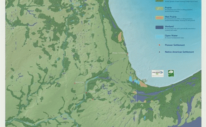
Chicago Growth (1830 – 2030)

Read more: Chicago Growth (1830 – 2030) →
MarsNatureSliderSpaceVideo
March 18, 2016 Alex

Raised relief rendering of Mars

Read more: Raised relief rendering of Mars →
Map of relief of Europe
Physical maps
March 18, 2016 Alex

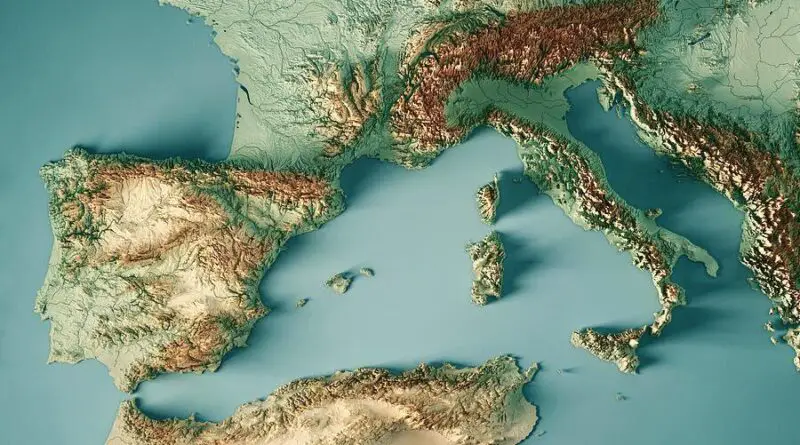
Raised-Relief Maps of Europe

In terms of shape, Europe is an assemblage of connected peninsulas and nearby islands. There are two largest peninsulas in Europe: mainland Europe and Scandinavia to the north, separated by the Baltic Sea. Three smaller peninsulas – Italy, Iberia, and the Balkans – emerge from the southern edge of the mainland.

Read more: Raised-Relief Maps of Europe →
CulinaryInteractive mapsInternetMap ProjectionsMapping StereotypesNews
March 18, 2016 Alex

Unfiltered news

Topics and places the world is reporting on right now. Explore what shapes our different perspectives.

Read more: Unfiltered news →
Climate ChangeCrime mapsDot mapsEnvironment mapsInfographicsInternet
March 18, 2016 Alex

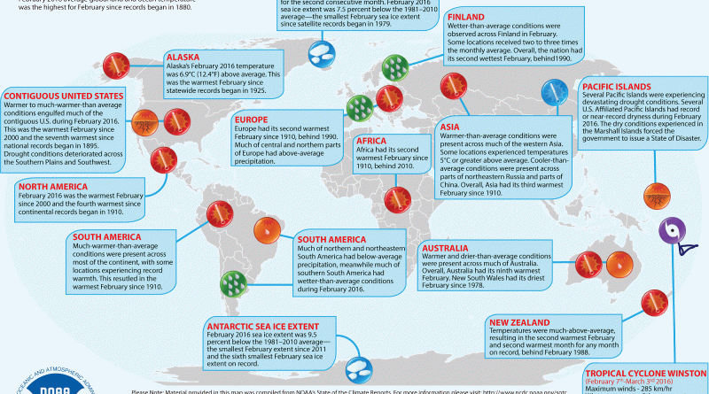
February 2016: Global Significant Climate Events Map

GLOBAL AVERAGE TEMPERATURE February 2016 average global land and ocean temperature was the highest for February since records began in

Read more: February 2016: Global Significant Climate Events Map →
CartogramsWorld
March 18, 2016 Alex

Which person your African country googled the most

Footballers and hip-hop artists are the most popular people googled in Africa, this according to data provided to TIME by

Read more: Which person your African country googled the most →
BuildingInternetPolitical maps
March 18, 2016 Alex

Ohio GOP Results vs. Household Income

Read more: Ohio GOP Results vs. Household Income →
Persian gulf ethnicity map
Ethnic maps
March 18, 2016 Alex

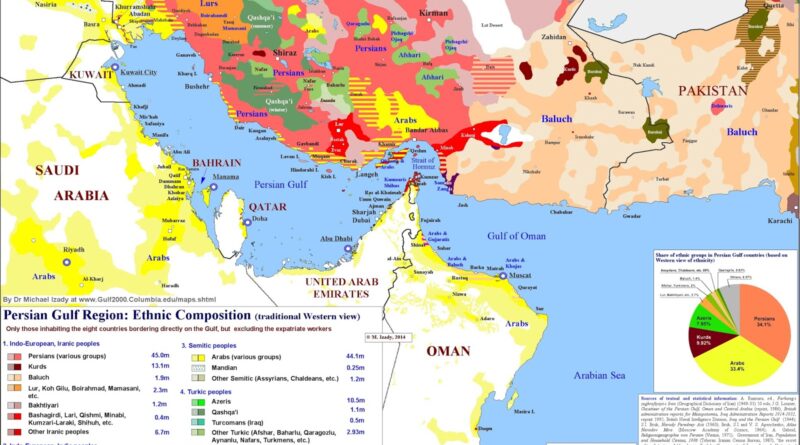
Persian Gulf Ethnicity Map

The Gulf region is more than oil and shipping lanes. It’s an arena of ethnic diversity. Using Dr. Michael Izady’s Gulf/2000 map, we explore how Persians, Arabs, Kurds, Azeris, and others share the coastline.

Read more: Persian Gulf Ethnicity Map →
World
March 18, 2016 Alex

The sunflower crop around the World

Read more: The sunflower crop around the World →
Crime mapsInteractive mapsMapping StereotypesReal estateWorld
March 17, 2016 Alex

Crime Index by country (2016)

Crime denotes an unlawful act punishable by a state.The most popular view is that crime is a category created by

Read more: Crime Index by country (2016) →
Mapping Health
March 17, 2016 Alex

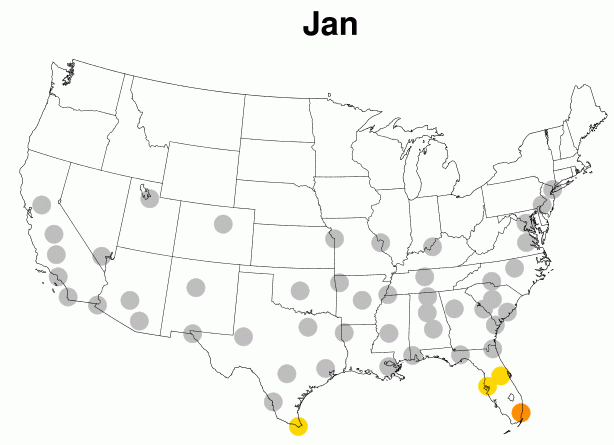
Which U.S. cities are at risk for a Zika outbreak?

So far in the United States, there have been 193 cases of Zika, all of them associated with travel or

Read more: Which U.S. cities are at risk for a Zika outbreak? →
Page 324 of 521« First«...320321322323324325326327328...»Last »

Trending now

  • Steel production in 1800 mapped
    220 Years of Steel Production, Mapped From 1800 to 2025Oct 18, 2026
  • Best Value Mobile Data World Map
    Maps reveal what countries have the most affordable mobile dataAug 9, 2021
  • Stereotypes about the United States
    The stereotype map of every US StateOct 29, 2015

Related Products

  • Push pin maps
  • Globe drinks cabinets
  • Maps of the United States
  • Board games
  • Monopoly
  • Map-based strategy board games
  • History Board Games
  • Coloring Books
  • Handheld GPS
  • GPS Watches
  • GPS Trackers

Vivid Maps Tools

  • Convert Latitude/Longitude
  • Elevation Finder
  • Distance Calculator
  • Kilometers to Miles Distance & Length Converter
  • Weight Converter
  • Volume Converter
  • Daylight Comparison
  • Time Zone Converter
  • Antipodes Map
  • Find cities with a similar climate
  • Find cities with a similar climate (2050)
  • How hot cities could be in 2050
  • The U.S. Population Lines

Stay connected

Get the latest maps, insights and updates delivered to your inbox.

Unsubscribe anytime.

VividMaps

Maps that explain the world.

Beautiful, data-rich maps to help you understand our world — its people, places and connections.

Explore

World map World atlas Map posters Globes

Company

About Privacy Contact

Stay connected

Follow us for the latest maps, insights and updates.

Independent WebsiteVirusScanner trust report for vividmaps.com
© 2026 Vivid Maps. All rights reserved.
A more connected world