
GDP Density
GDP is distributed very unevenly in the world. Japan, Germany, United Kingdom, South Korea, and microstates (San Marino, Monaco) have the highest gross domestic product per square kilometer in the world.
Read more: GDP DensityMost commonly spoken language other than English or Spanish
Most commonly spoken language other than English or Spanish (2017) Most commonly spoken language other than English or Spanish (2015)
Read more: Most commonly spoken language other than English or SpanishMost common country of origin of legal immigrants other than Mexico
The U.S. has more immigrants than any other nation in the world. Nowadays, about 45 million people, comprising 14% of the national population, live in the U.S. The population of immigrants is also wildly diverse, with just almost every nation in the world represented among American immigrants.
Read more: Most common country of origin of legal immigrants other than MexicoWe are living in the Age of Humans
– 7.2 billion people inhabit the Earth as of 2014, according to the U.S. Census Bureau. By 2050, the population
Read more: We are living in the Age of Humans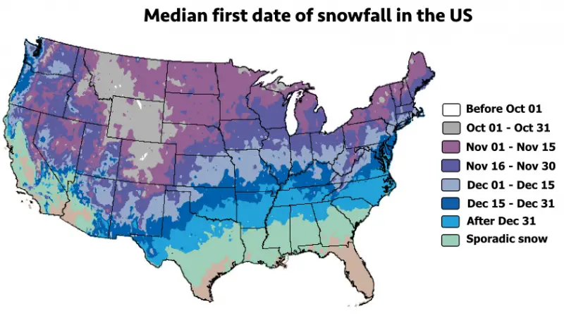
Snowiest places in the United States mapped
Snow continuously has challenged humans but also has attracted and fascinated us. It changes the landscape around us, even altering the sounds we hear and the odors we breathe. For some, the expectation of coming snowstorms is like for Santa Claus on Christmas. But the charm and delight ever are compensated by anxiety and danger.
Read more: Snowiest places in the United States mappedQuality of Death Index (2015)
The Quality of Death Index was devised and constructed by an Economist Intelligence Unit (EIU) research team led by Trisha
Read more: Quality of Death Index (2015)