Skip to content
VividMaps

  • Atlases
  • Map Posters
  • Scratch Maps
  • Globes
  • Videos
Political maps
October 31, 2015 Alex

Regimes in Africa in 1985 & 2012

Africa is turning democratic. Via ourworldindata.org

Read more: Regimes in Africa in 1985 & 2012 →

Interactive mapsMapping Stereotypes
October 31, 2015 Alex

Europe according to the Vikings 1000

Read more: Europe according to the Vikings 1000 →
BusinessWorld
October 31, 2015 Alex

Countries with IKEA stores

Read more: Countries with IKEA stores →
HumanInfographicsMapping Stereotypes
October 31, 2015 Alex

This map shows where people do and don’t like to be touched

See also: – This map shows where people do and don’t like to be touched

Read more: This map shows where people do and don’t like to be touched →
Mapping Health
October 31, 2015 Alex

Percentage of Americans in 2015 who do not have health insurance

Read more: Percentage of Americans in 2015 who do not have health insurance →
Mapping Stereotypes
October 30, 2015 Alex

Most & least remembered states

Most and least remembered states based on 12 Sporcle responses.

Read more: Most & least remembered states →
Mapping HealthWorld
October 30, 2015 Alex

Estimated tuberculosis (TB) mortality excluding TB deaths among HIV-positive people

Via undispatch.com

Read more: Estimated tuberculosis (TB) mortality excluding TB deaths among HIV-positive people →
AgricultureInternetMapping Stereotypes
October 30, 2015 Alex

Gulf stream meanders and temperature

Read more: Gulf stream meanders and temperature →
CitiesInteractive mapsPollution
October 30, 2015 Alex

London average major road and rail noise levels

Hover over a noise segment and turn up the volume.

Read more: London average major road and rail noise levels →
LawsWorld
October 30, 2015 Alex

Youth bullying victimisation and frequent physical fighting among 13-year

Read more: Youth bullying victimisation and frequent physical fighting among 13-year →
GoogleInternetWars
October 30, 2015 Alex

No. of Wars and Conflicts in Africa since 1950

Read more: No. of Wars and Conflicts in Africa since 1950 →
World
October 29, 2015 Alex

Freedom on the Net 2015

Via freedomhouse.org

Read more: Freedom on the Net 2015 →
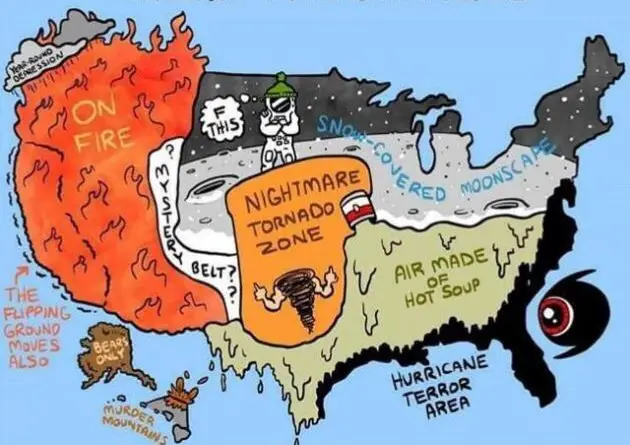
Stereotypes about the United States
Mapping Stereotypes
October 29, 2015 Alex

The stereotype map of every US State

Yanko Tsvetkov and an AI each gave every US state a stereotype. Here are both maps, plus more stereotype maps of the country, with a few labels fact-checked.

Read more: The stereotype map of every US State →
Page 398 of 521« First«...394395396397398399400401402...»Last »

Trending now

  • Settlements and native tribes in North America in 1650 Mapped
    The Americas in 1650, Just Before the Dutch and Swedish Colonies EndedOct 22, 2026
  • Proportion of people aged 4 and under
    U.S. population aged 0-4 yearJul 23, 2019
  • Regional map of giraffes' patterns in Africa
    Regional map of giraffes’ patterns in AfricaMay 6, 2019

Related Products

  • Push pin maps
  • Globe drinks cabinets
  • Maps of the United States
  • Board games
  • Monopoly
  • Map-based strategy board games
  • History Board Games
  • Coloring Books
  • Handheld GPS
  • GPS Watches
  • GPS Trackers

Vivid Maps Tools

  • Convert Latitude/Longitude
  • Elevation Finder
  • Distance Calculator
  • Kilometers to Miles Distance & Length Converter
  • Weight Converter
  • Volume Converter
  • Daylight Comparison
  • Time Zone Converter
  • Antipodes Map
  • Find cities with a similar climate
  • Find cities with a similar climate (2050)
  • How hot cities could be in 2050
  • The U.S. Population Lines

Stay connected

Get the latest maps, insights and updates delivered to your inbox.

Unsubscribe anytime.

VividMaps

Maps that explain the world.

Beautiful, data-rich maps to help you understand our world — its people, places and connections.

Explore

World map World atlas Map posters Globes

Company

About Privacy Contact

Stay connected

Follow us for the latest maps, insights and updates.

Independent WebsiteVirusScanner trust report for vividmaps.com
© 2026 Vivid Maps. All rights reserved.
A more connected world