United States
Maps of the US
The battle fronts of Europe
World War II in Europe featured several pivotal battlefronts that significantly influenced the course of the conflict. The Eastern Front witnessed brutal clashes between Nazi Germany and the Soviet Union, with iconic battles like Stalingrad and Kursk shaping the war’s intensity. The Western Front, marked by the D-Day invasion in 1944, saw Allied forces establishing a second front against Nazi-occupied Europe. The Mediterranean and North African campaigns, including battles like El Alamein, played crucial roles in halting Axis advances. The diverse battlefronts collectively contributed to the eventual defeat of Nazi Germany in 1945.
Read MoreDensity comparison of six american metropolises
Based on 2010 Census population data by census block. Census Blocks with Population < 10 are not included. Other urbanized
Read MoreThe United States and Europe at Night
U.S. Europe
Read MoreWettest and Driest Seasons/Months in the United States
Precipitation varies significantly across the U.S. Late summer and autumn tropical cyclones bring rain, dropping across the Atlantic states and Gulf area. In winter and spring, Pacific storm systems get Hawaii and the western U.S. states most precipitation. Low-pressure moving up the U.S.’s eastern shore brings cold season precipitation to the Mid-West and Northeast U.S. states.
Read MoreHow Healthy (or Unhealthy) Your Neighborhood Is ?
The 500 Cities project is a collaboration between CDC, the Robert Wood Johnson Foundation, and the CDC Foundation. The purpose
Read More72 Million Americans Depend on Drinking Water From Small Streams
The data EWG used are drawn from a 2009 EPA study that analyzed “regional patterns of dependence on intermittent, ephemeral
Read More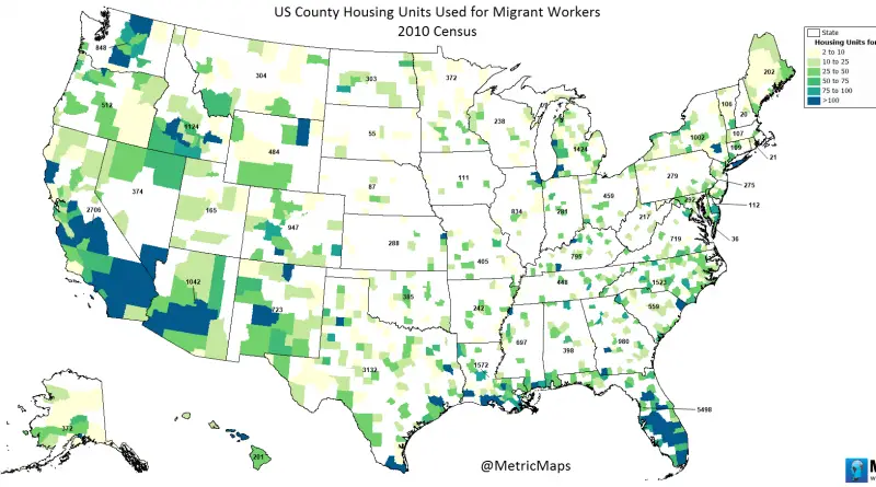
U.S. County Housing Units Used for Migrant Workers
www.metricmaps.org/2017/03/02/us-county-housing-units-used-for-migrant-workers
Read More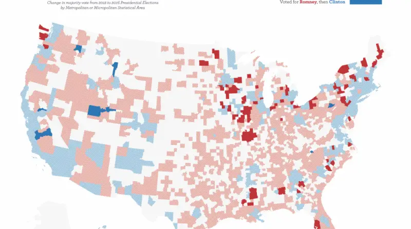
Moving toward Trump
Change in majority vote from 2012 to 2016 Presidential Elections by Metropolitan or Micropolitan Statistical Area. 80 cities that flipped
Read More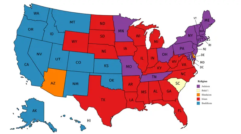
Largest non-Christian religion in each U.S. state
Source: Reddit / user: Jedicobra Related posts: – Overall religiosity by U.S. State – Catholic Ecclesiastical Provinces in the United
Read More