Hourly traffic on the United States Interstate, visualized as a living circulatory system
Highway networks are often compared to the human circulatory system, an analogy that works on many levels. The hierarchical structure
Read More
Maps of the US
Highway networks are often compared to the human circulatory system, an analogy that works on many levels. The hierarchical structure
Read MoreHow far could you theoretically see from the top of Mount Everest in a perfectly clear weather, with perfect vision
Read More
The Displacement Alert Project Map (Dap.Map) is a building-by-building, web-based interactive map for New York City designed to show where
Read MoreRelated posts: – New York’s Subway Deserts – New York City boroughs journey to work-driving ca alone vs. walk/public transportation
Read More“Graphic presentation of data” from the 1934 Real Property Inventory Report, published by LaGuardia’s Committee on City Planning, depicting the
Read MorePopulation without health insurance coverage. Via census.gov Related posts: – Percentage of Americans in 2015 who do not have health insurance
Read More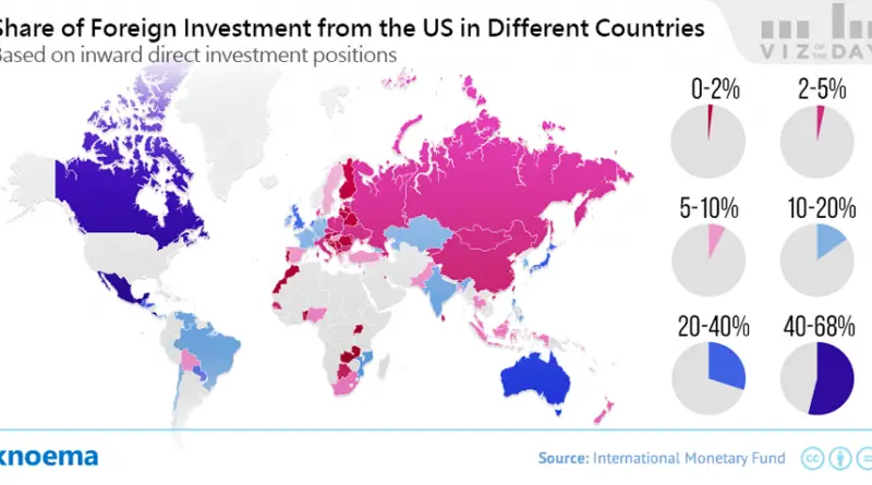
During 2015, outward United States net foreign direct investment reached $345.1 billion, an amount that was not only 21.6 percent
Read MoreEstimates of the number of American Indians have been made since the European discovery of the continent. Various authorities estimate that there were approximately 1,000,000 native inhabitants within the continental United States when Columbus reached the New World. They coexisted as some 500 tribes, varying in size from a few dozen to several thousand, speaking more than 300 languages.
Read More
America’s 4 million miles of roads aren’t just pavement—they’re history. Discover what road names reveal about our towns, cities, and regions.
Read More