
Skip to content
VividMaps

  • Atlases
  • Map Posters
  • Scratch Maps
  • Globes
  • Videos
CartogramsCultural cartographyEnergy
July 15, 2017 Alex

Map showing the relative size of each of the United States if based on Electrical energy sold for light and power (1921)
“Relative size of each of the United States if based on electrical energy sold for light and power in 1921

Read more: Map showing the relative size of each of the United States if based on Electrical energy sold for light and power (1921) →
Climate
July 14, 2017 Alex

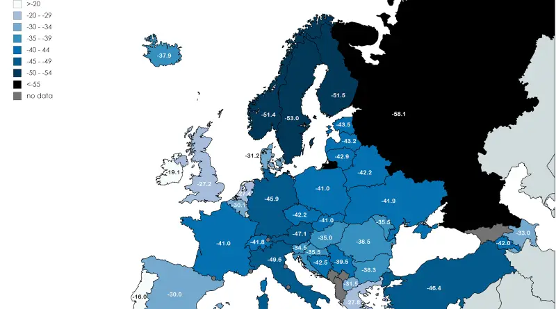
Coldest temperature recorded in each country in Europe

Reddit user: Jeleki Related post: – Find cities with similar climate

Read more: Coldest temperature recorded in each country in Europe →
Size comparison maps
July 14, 2017 Alex

Points closer to Texas than the opposite sides of Texas are to each other

Points in the red secion are closer to somewhere in Texas than the opposite sides of Texas are to each

Read more: Points closer to Texas than the opposite sides of Texas are to each other →
Climate
July 13, 2017 Alex

Count of Days 79-2011 Where Heat Index Exceeded 105 F for U.S. County

Source: www.metricmaps.org Drought Duration by U.S. County Drought severity and duration in the U.S. (2010 – 2016) Source: www.vividmaps.com

Read more: Count of Days 79-2011 Where Heat Index Exceeded 105 F for U.S. County →
Climate
July 13, 2017 Alex

Peak month for precipitation by U.S. county

Source: www.metricmaps.com

Read more: Peak month for precipitation by U.S. county →
Map of Modern and Historical range of the elephants
Animals
July 13, 2017 Alex

Modern and Historical range of the elephants

Elephant populations have decreased by 62% over the last decade. The main historical factors behind elephants’ decline are the demand for ivory, habitat loss, habitat degradation, and fragmentation.

Read more: Modern and Historical range of the elephants →
World
July 13, 2017 Alex

Average daily steps by country

Million people die from causes associated with physical inactivity every year. The study, appearing in Nature, used data captured from

Read more: Average daily steps by country →
3D mapsRelief maps
July 12, 2017 Alex

Mt. Hood Oregon (3429 meters)

Read more: Mt. Hood Oregon (3429 meters) →
Old mapsPopulation
July 12, 2017 Alex

U.S. county natural increase in population (2010 – 2016)

Source: metricmaps.org

Read more: U.S. county natural increase in population (2010 – 2016) →
World
July 12, 2017 Alex

A giant, trillion-tonne iceberg has just split away from Antarctica

The iceberg, which has an area of roughly 4 times the size of London at 5800 km2, was part of

Read more: A giant, trillion-tonne iceberg has just split away from Antarctica →
CartogramsEconomic mapsSliderVivid mapsWorld
July 11, 2017 Alex

Mean and median wealth per adult

Mean wealth per adult Median wealth per adult Cartogram of the median wealth per adult (2016) Related posts: – Mean and

Read more: Mean and median wealth per adult →
Real estate
July 11, 2017 Alex

Manhattan Skyscraper Explorer

Related posts – How tall will new buildings in my New York City neighborhood be? – If Manhattan was a mountain… – Building

Read more: Manhattan Skyscraper Explorer →
Mapping Health
July 11, 2017 Alex

This Map Shows How Some U.S. Counties Are Prescribing Way More Opioids Than Others

Doctors in some U.S. counties prescribed up to six times more addictive pain pills than others in 2015.  Around two

Read more: This Map Shows How Some U.S. Counties Are Prescribing Way More Opioids Than Others →
Page 136 of 521« First«...132133134135136137138139140...»Last »

Trending now

  • Settlements and native tribes in North America in 1650 Mapped
    The Americas in 1650, Just Before the Dutch and Swedish Colonies EndedOct 22, 2026
  • Map of New Netherland and New Sweden
    The Dutch and Swedish Colonies That Once Held the Mid-Atlantic CoastOct 7, 2023
  • Map of greek colonies
    Ancient Greek Colonies on the Map, From Marseille to CrimeaOct 21, 2026

Related Products

  • Push pin maps
  • Globe drinks cabinets
  • Maps of the United States
  • Board games
  • Monopoly
  • Map-based strategy board games
  • History Board Games
  • Coloring Books
  • Handheld GPS
  • GPS Watches
  • GPS Trackers

Vivid Maps Tools

  • Convert Latitude/Longitude
  • Elevation Finder
  • Distance Calculator
  • Kilometers to Miles Distance & Length Converter
  • Weight Converter
  • Volume Converter
  • Daylight Comparison
  • Time Zone Converter
  • Antipodes Map
  • Find cities with a similar climate
  • Find cities with a similar climate (2050)
  • How hot cities could be in 2050
  • The U.S. Population Lines

Stay connected

Get the latest maps, insights and updates delivered to your inbox.

Unsubscribe anytime.

VividMaps

Maps that explain the world.

Beautiful, data-rich maps to help you understand our world — its people, places and connections.

Explore

World map World atlas Map posters Globes

Company

About Privacy Contact

Stay connected

Follow us for the latest maps, insights and updates.

Independent WebsiteVirusScanner trust report for vividmaps.com
© 2026 Vivid Maps. All rights reserved.
A more connected world