Brazil’s Upside-Down World Map
Explore Brazil’s south-up map and discover how changing map orientation can shift your entire view of the world.
Read more: Brazil’s Upside-Down World Map

Explore Brazil’s south-up map and discover how changing map orientation can shift your entire view of the world.
Read more: Brazil’s Upside-Down World Map
What if state and county borders weren’t just lines, but barriers shaped by elevation, rainfall, and population? This series of 3D maps that do just that—transforming geographic and demographic data into eye-catching visualizations.
Read more: United States Border Walls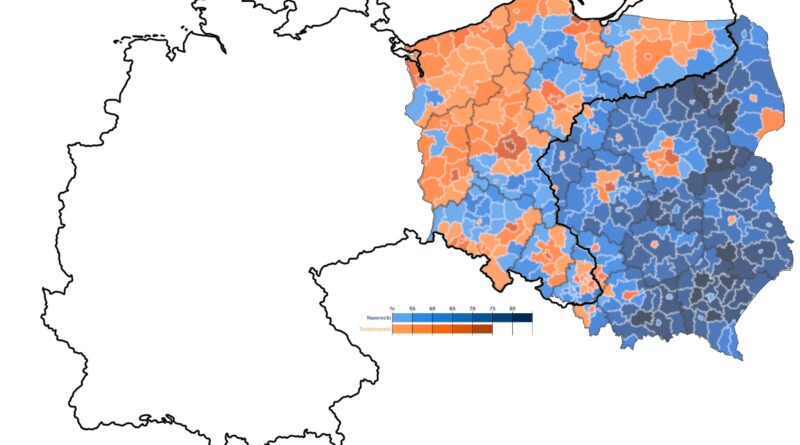
A century after the empires that once ruled Poland vanished, their shadows still linger. This post explores how old imperial borders — now invisible — continue to shape Polish elections.
Read more: Phantom Borders: How Poland’s Past Still Shapes Its Politics
Over the past century, Norway’s untouched forests have dramatically disappeared. What right do we have to lecture the rest of the world if the green heart of a developed, wealthy country can disappear so silently?
Read more: Mapping the Disappearance of Norway’s Untouched Forests
Hudson Bay is large enough to swallow Great Britain entirely—and have space left over. Dive into this comparison of their surface area, depth, and height to learn just how massive Canada’s inland sea actually is.
Read more: Hudson Bay vs. Great Britain: You could fit Great Britain entirely into Canada’s Hudson Bay!
A detailed map of parental leave laws by U.S. state shows where new parents are legally guaranteed paid time off—and where they aren’t.
Read more: How Much Parental Leave Do U.S. States Require?
A fascinating sunshine hours map of Europe reveals staggering solar variation across the continent. The visualization shows how latitude, ocean currents, winds, terrain, and continentality create unique sunshine patterns in each region.
Read more: Europe’s Sunshine Map
Households in Hawaii have the most cash in the bank—over $43,000—while Mississippi residents hold under $2,000. Discover how median bank balances vary widely by state, and where yours lands in the rankings.
Read more: States Where Americans Have the Most Cash in the Bank
Howard Burke’s unusual propaganda map from 1940 depicted a split China ruled by the Soviet Union and Japan. History changed course decades later, completely reversing the balance of power.
Read more: “Japan and Russia Will Divide China” (1940 Propaganda Map)
From ancient civilizations to the world’s superpowers today, the journey to population milestones is a fascinating ride. Find out how countries reached significant population milestones — from 20 million to 2 billion.
Read more: When Nations Crossed Population Milestones
Most Popes throughout history were born in Italy—but a closer look reveals an interesting geographic distribution across continents. Discover where Popes were born and how shifts in the scope of the Catholic Church have impacted its leadership.
Read more: Where Were the Popes Born? A Map of Papal Origins Through Time
How big is a city, really? Instead of relying on inconsistent metro definitions, this post maps and compares Europe’s largest cities by population within 30 km circles. From Moscow to Madrid, see which urban areas dominate when the playing field is circular.
Read more: Europe’s Largest Cities Through 30km Population Circles
If only white men cast ballots, how would the 2024 presidential election map change? We look at the results by state, point out significant changes since 2020, and talk about the implications for American voting patterns.
Read more: What If Only White Men Voted in the 2024 U.S. Election?