Skip to content
VividMaps

  • Atlases
  • Map Posters
  • Scratch Maps
  • Globes
  • Videos
Mapping StereotypesNaturePolitical maps
June 9, 2017 Alex

Results of 2017 UK General Election

Full Results of 2017 UK Election:– Conservatives (right-wing, pro-hard Brexit): 318 seats (42.4% vote share)– Labour (left-wing, pro-soft Brexit): 261

Read more: Results of 2017 UK General Election →

Physical maps
June 9, 2017 Alex

United States Elevation

The United States exhibits a wide range of elevations, with its geography encompassing low-lying coastal regions, high mountain ranges, plateaus, deserts, and vast plains. This diversity of elevations contributes to the country’s unique and varied landscapes, making it a place of immense natural beauty and geographic interest.

Read more: United States Elevation →
TravelWorld
June 9, 2017 Alex

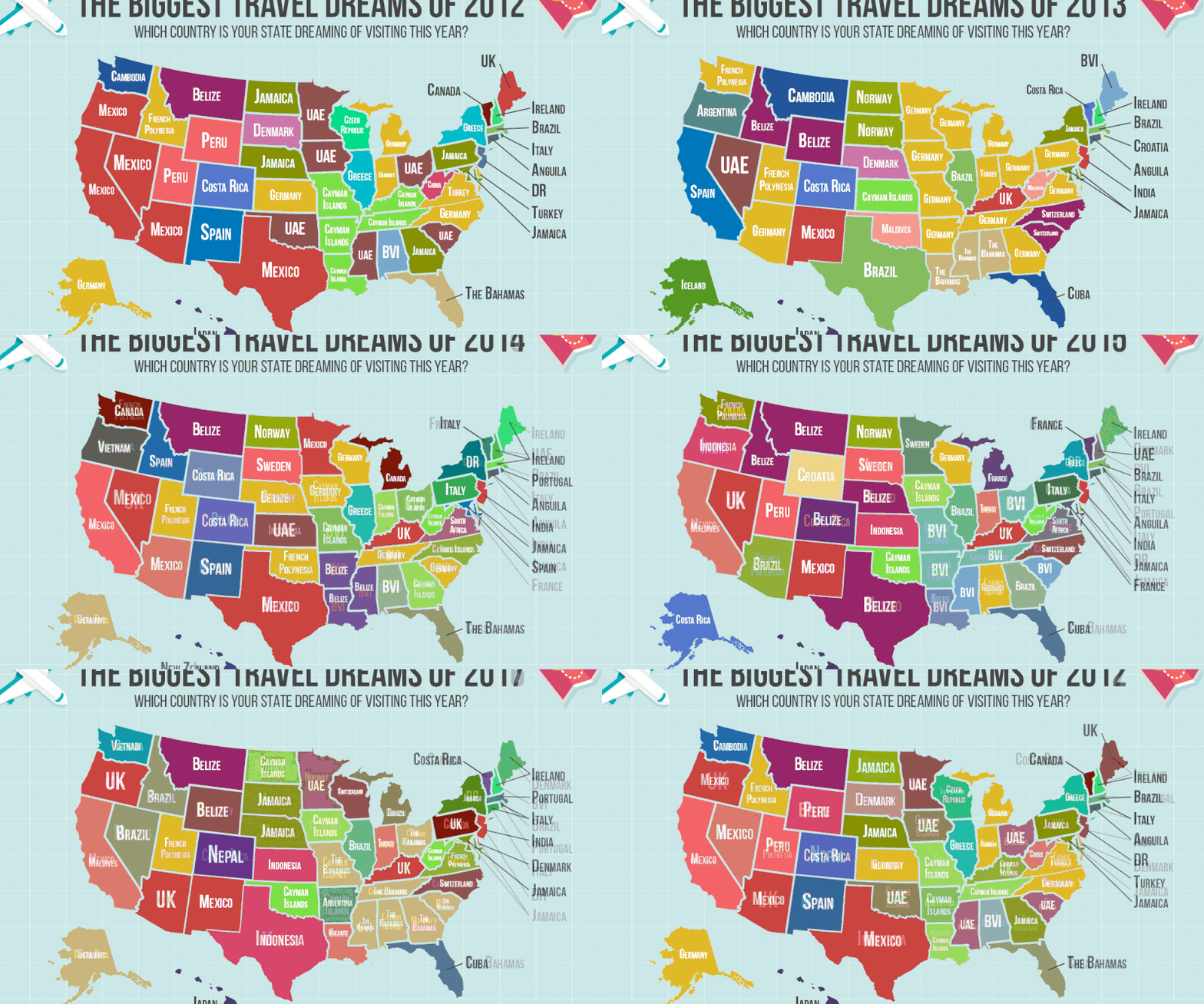
Top desired travel destination for each U.S. state (2012 – 2017)

Top desired travel destination for each U.S. state over the last 5 years.

Read more: Top desired travel destination for each U.S. state (2012 – 2017) →
Political maps
June 8, 2017 Alex

U.S. states governors and senators by party affiliation from 1775 to 2017

U.S. States governors by party affiliation (1775 – 2017) U.S. States senators by party affiliation (1775 – 2017)

Read more: U.S. states governors and senators by party affiliation from 1775 to 2017 →
CarsMexicoNature
June 8, 2017 Alex

U.S. State Highway Marker Shields

Reddit user: glikithvinayaka

Read more: U.S. State Highway Marker Shields →
Environment mapsInfographics
June 8, 2017 Alex

New York Seascape

The New York seascape – 16,000 square miles of ocean from Montauk, New York, to Cape May, New Jersey –

Read more: New York Seascape →
Space
June 8, 2017 Alex

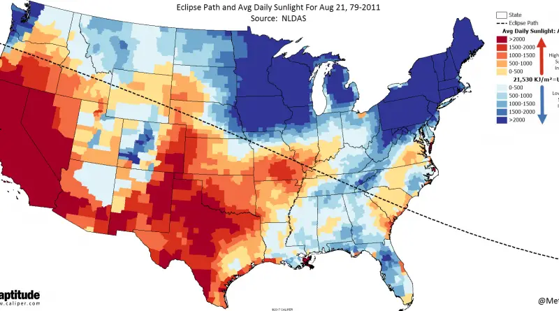
Great American Eclipse

ArcGIS.com Eclipse path and average daily sunlight www.metricmaps.org/2017/06/07/eclipse-path-and-avg-daily-sunlight/ Related posts: – Population access & estimated visitation on eclipse day –

Read more: Great American Eclipse →
Animated mapsCitiesEconomic mapsHistorical MapsSliderVivid maps
June 7, 2017 Alex

Household wealth levels in Europe (2000 – 2016)

Median wealth per adult by country, 2000 – 2016 Youtube Median wealth per adult by country, 2016 Related post: – Debt

Read more: Household wealth levels in Europe (2000 – 2016) →
Climate
June 7, 2017 Alex

The lowest temperature recorded in each state/province of the US and Canada in Celsius & Fahrenheit

Related post:– Find cities with similar climate

Read more: The lowest temperature recorded in each state/province of the US and Canada in Celsius & Fahrenheit →
Crime mapsInteractive mapsMapping StereotypesVivid maps
June 7, 2017 Alex

Origin of Heroin in the U.S.

Reddit user: NelsonMinar Source: Jonathan Wain & Richard Jonson via National Post Related posts: – The stunning spread of the opioid painkiller

Read more: Origin of Heroin in the U.S. →
Economic mapsWorld
June 7, 2017 Alex

Regional Trade Blocs

Reddit user: alectprasad

Read more: Regional Trade Blocs →
Interactive mapsInternetMapping HealthMapping Stereotypes
June 6, 2017 Alex

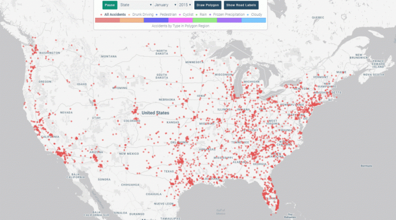
Mapping Traffic Fatalities on America’s Roads

The number of traffic fatalities in the U.S. increased over 7% in 2015 relative to the previous year, the largest

Read more: Mapping Traffic Fatalities on America’s Roads →
Historical MapsMapping StereotypesWars
June 6, 2017 Alex

Map of Europe during World War I Respective Propaganda Posters

Reddit user: teerawk123 Related post: – A collection of satirical maps of Europe

Read more: Map of Europe during World War I Respective Propaganda Posters →
Page 146 of 521« First«...142143144145146147148149150...»Last »

Trending now

  • Soviet detailed map
    Detailed Cold War-era Soviet military map of the San Francisco Bay area (1980)Oct 22, 2017
  • Human races of the 19th century
    How Has Our View of Human Diversity Changed Since the 19th Century?Oct 22, 2017
  • World map of Y-DNA Haplogroups
    World map of Y-DNA HaplogroupsMay 17, 2017

Related Products

  • Push pin maps
  • Globe drinks cabinets
  • Maps of the United States
  • Board games
  • Monopoly
  • Map-based strategy board games
  • History Board Games
  • Coloring Books
  • Handheld GPS
  • GPS Watches
  • GPS Trackers

Vivid Maps Tools

  • Convert Latitude/Longitude
  • Elevation Finder
  • Distance Calculator
  • Kilometers to Miles Distance & Length Converter
  • Weight Converter
  • Volume Converter
  • Daylight Comparison
  • Time Zone Converter
  • Antipodes Map
  • Find cities with a similar climate
  • Find cities with a similar climate (2050)
  • How hot cities could be in 2050
  • The U.S. Population Lines

Stay connected

Get the latest maps, insights and updates delivered to your inbox.

Unsubscribe anytime.

VividMaps

Maps that explain the world.

Beautiful, data-rich maps to help you understand our world — its people, places and connections.

Explore

World map World atlas Map posters Globes

Company

About Privacy Contact

Stay connected

Follow us for the latest maps, insights and updates.

Independent WebsiteVirusScanner trust report for vividmaps.com
© 2026 Vivid Maps. All rights reserved.
A more connected world