Skip to content
VividMaps

  • Atlases
  • Map Posters
  • Scratch Maps
  • Globes
  • Videos
InternetWorld
May 30, 2017 Alex

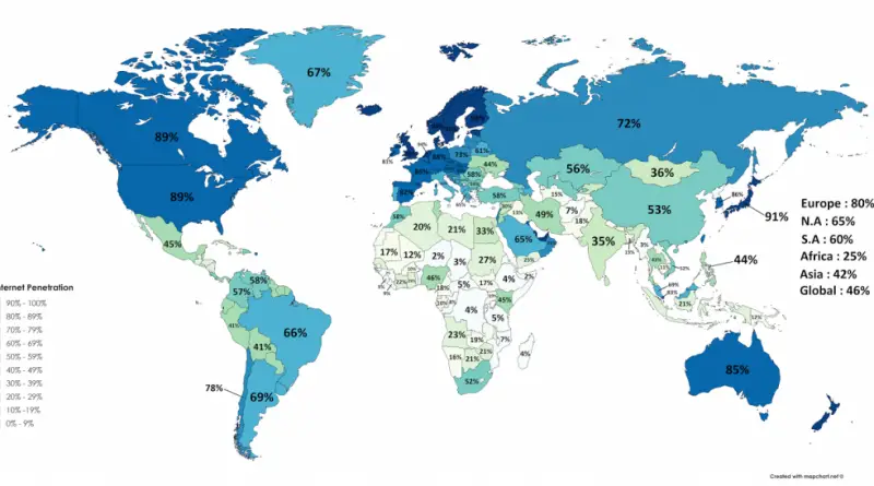
Maps that explain the internet

Map of the entire Internet in May 1973 All the devices in the world connected to the Internet A map

Read more: Maps that explain the internet →

InfographicsInternetSpaceVivid maps
May 30, 2017 Alex

Population access & estimated visitation on eclipse day

On August 21, 2017, a total solar eclipse crosses the United States from Oregon to South Carolina. The closest destinations

Read more: Population access & estimated visitation on eclipse day →
GermanyHistorical MapsMapping StereotypesVideoVivid maps
May 30, 2017 Alex

Map of Germany in 962 AD

Read more: Map of Germany in 962 AD →
Interactive mapsInternetMapping StereotypesPopulationWorld
May 30, 2017 Alex

World population – uneven development

Read more: World population – uneven development →
Economic mapsSliderVivid mapsWorld
May 29, 2017 Alex

Change in USD exchange rate

Change in USD exchange rate (%) Japan 19.3 New Zealand 5.3 Indonesia 0.9 Czech Republic 0.4 Kuwait 0.2 United States

Read more: Change in USD exchange rate →
InternetLawsMapping StereotypesPopulation
May 29, 2017 Alex

Europe Population Density in 3D

Below the 3D Europe population density maps.

Read more: Europe Population Density in 3D →
CitiesEnvironment mapsMapping StereotypesPollutionPopulation
May 29, 2017 Alex

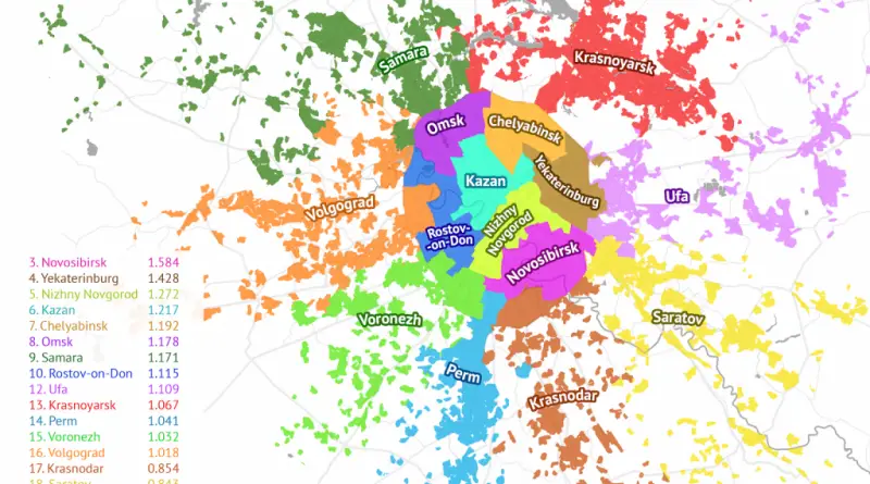
Rubber Moscow

Russian cities whose populations fit inside the Moscow metro area. Source: sashat.me

Read more: Rubber Moscow →
Dog Breeds mapped
AnimalsOld maps
May 29, 2017 Alex

Dogs of the World

Dogs were the first domesticated animals. They have accompanied humans for about 30,000 years. Scientists generally acknowledge that all dogs share a common wolf ancestor. Nowadays, humans have bred hundreds of various domestic dog breeds. The maps below show dogs of the world and their nations of origin.

Read more: Dogs of the World →
Climate ChangeEnvironment maps
May 28, 2017 Alex

Coastlines of the Ice Age

The ice age is a long period of decrease in our planet’s surface and atmosphere temperature, resulting in the growth of continental and polar ice sheets and mountain glaciers. During the last ice age about one-third of the Earth’s surface was covered by ice.

Read more: Coastlines of the Ice Age →
ForecastsHistorical MapsSliderWorld
May 28, 2017 Alex

Animated history of Southern Africa

Read more: Animated history of Southern Africa →
World
May 28, 2017 Alex

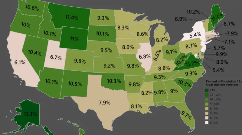
Percent of Population 18 and Over That are Veterans

Reddit user: mapsturbater

Read more: Percent of Population 18 and Over That are Veterans →
DemographyInteractive mapsJobMapping Stereotypes
May 27, 2017 Alex

Employment characteristics of married couples by U.S. county

Source: metricmaps.org

Read more: Employment characteristics of married couples by U.S. county →
Cultural cartographyPolitical maps
May 26, 2017 Alex

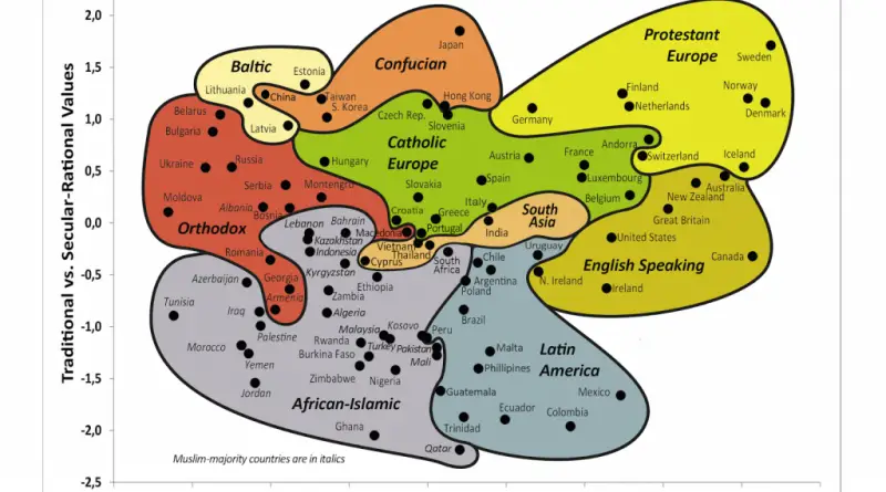
Inglehart–Welzel Cultural Map

The Inglehart–Welzel cultural map shows empirical evidence of substantial cultural transformation and the perseverance of distinctive cultural traditions. The central theory holds that socioeconomic development is connected with a broad syndrome of distinct value orientations.

Read more: Inglehart–Welzel Cultural Map →
Page 149 of 521« First«...145146147148149150151152153...»Last »

Trending now

  • Soviet detailed map
    Detailed Cold War-era Soviet military map of the San Francisco Bay area (1980)Oct 22, 2017
  • Human races of the 19th century
    How Has Our View of Human Diversity Changed Since the 19th Century?Oct 22, 2017
  • World map of Y-DNA Haplogroups
    World map of Y-DNA HaplogroupsMay 17, 2017

Related Products

  • Push pin maps
  • Globe drinks cabinets
  • Maps of the United States
  • Board games
  • Monopoly
  • Map-based strategy board games
  • History Board Games
  • Coloring Books
  • Handheld GPS
  • GPS Watches
  • GPS Trackers

Vivid Maps Tools

  • Convert Latitude/Longitude
  • Elevation Finder
  • Distance Calculator
  • Kilometers to Miles Distance & Length Converter
  • Weight Converter
  • Volume Converter
  • Daylight Comparison
  • Time Zone Converter
  • Antipodes Map
  • Find cities with a similar climate
  • Find cities with a similar climate (2050)
  • How hot cities could be in 2050
  • The U.S. Population Lines

Stay connected

Get the latest maps, insights and updates delivered to your inbox.

Unsubscribe anytime.

VividMaps

Maps that explain the world.

Beautiful, data-rich maps to help you understand our world — its people, places and connections.

Explore

World map World atlas Map posters Globes

Company

About Privacy Contact

Stay connected

Follow us for the latest maps, insights and updates.

Independent WebsiteVirusScanner trust report for vividmaps.com
© 2026 Vivid Maps. All rights reserved.
A more connected world