Skip to content
VividMaps

  • Atlases
  • Map Posters
  • Scratch Maps
  • Globes
  • Videos
Mapped: Canada vs Europe Latitude
CitiesClimate
July 22, 2026 Alex

Canada Is Much Further South Than Most Maps Suggest

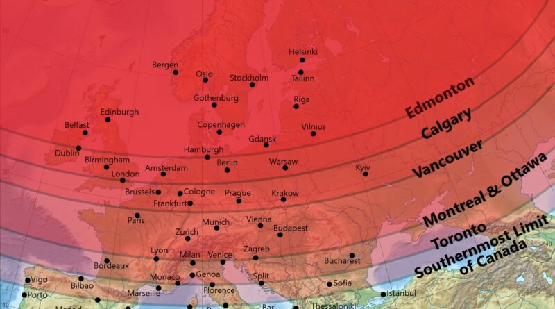
Canada looks like a country of snow and endless winter on the map, yet its six biggest cities land at the same latitude as London, Paris and even Florence.

Read more: Canada Is Much Further South Than Most Maps Suggest →
Mapped: Does You U.S. State Require Front License Pltates?
Laws
July 19, 2026 Alex

Which US States Require a Front License Plate

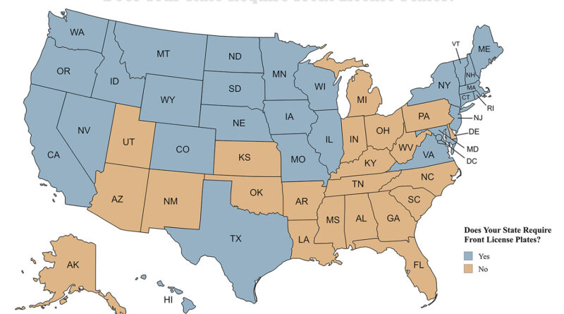
23 states don’t require a front license plate, and the list keeps growing. Utah joined most recently in January 2025, and a bill to make Virginia the next one died in the legislature earlier this year.

Read more: Which US States Require a Front License Plate →
World map of Gambling Friendliness across countries
Business
July 18, 2026 Alex

Gambling Laws Around the World

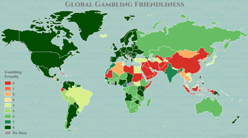
The oldest gambling dice are over 5,000 years old. The global gambling market hit $650 billion in 2026. Whether a bet is legal where you are is a completely different question. Five world maps break down casino gambling, online casinos, sports betting and online betting for all 195 countries, plus a Gambling Friendliness score for each.

Read more: Gambling Laws Around the World →
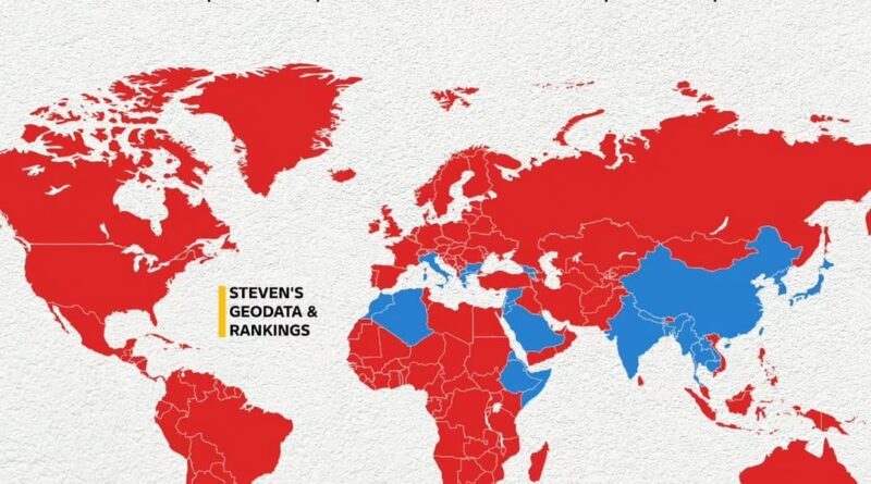
World map showing countries where at least one official language is written in a natively developed script (blue) and countries where no official languages use a native script (red)
Linguistic maps
July 12, 2026 Alex

Countries Where the Official Language Uses a Native Writing Script

Most of the world writes its official languages in alphabets that arrived from outside, whether Latin from Roman colonialism or Cyrillic from 9th-century Byzantine missionaries. Only about 44 of 195 countries use a script that grew from within their own tradition.

Read more: Countries Where the Official Language Uses a Native Writing Script →
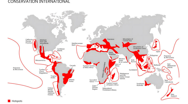
The map that shows key hotspots in the world.
Environment maps
July 7, 2026 Alex

Earth’s Biodiversity Hotspots, Mapped

About one million species are currently sliding toward extinction, and most of what remains is concentrated in a surprisingly small slice of the planet. This map traces 33 of the regions carrying that weight, from California’s redwood groves to the volcanic forests of Chile and the islands of Wallacea.

Read more: Earth’s Biodiversity Hotspots, Mapped →
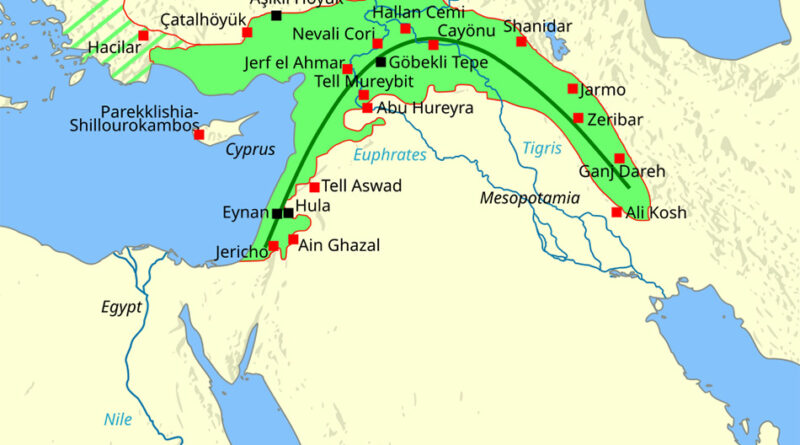
Fertile crescent mapped
Historical Maps
July 5, 2026 Alex

The Fertile Crescent Around 7500 BCE

A single map tracking the world around 7500 BCE lines up eighteen sites tied to the origins of farming, from Göbekli Tepe in Turkey to Jericho in the West Bank. Only one of them still has people living on it today.

Read more: The Fertile Crescent Around 7500 BCE →
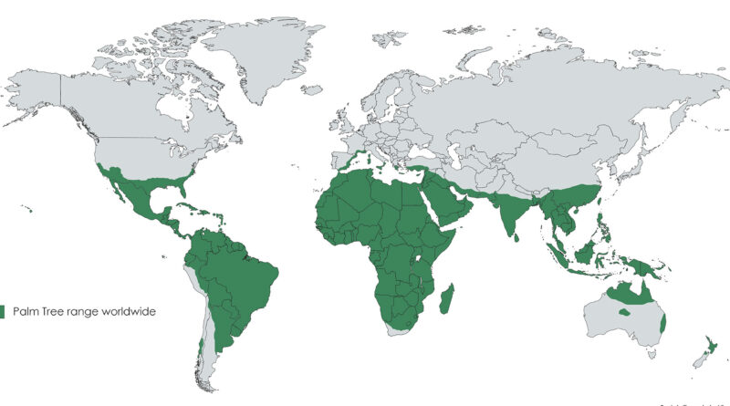
Places where palm trees grow
Environment maps
June 21, 2026 Alex

The Native Range of Palm Trees Around the World

A palm has no bark, no growth rings, and only one growing point for its whole life, yet roughly 2,600 species have found ways to survive everywhere from rainforest floors to Mediterranean cliffs.

Read more: The Native Range of Palm Trees Around the World →
Taiwan ethnic composition mapped
Ethnic maps
June 20, 2026 Alex

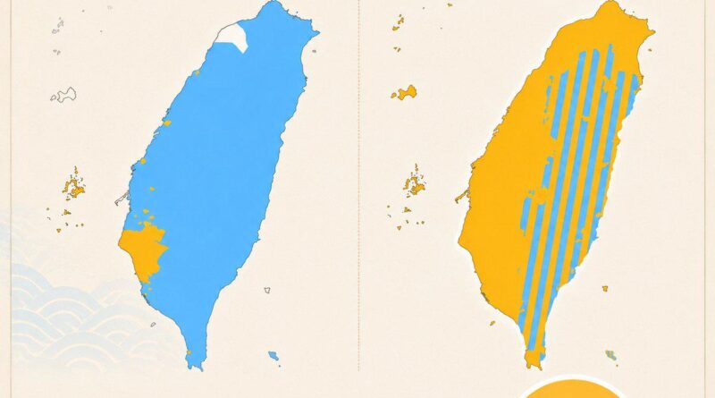
How Much Taiwan’s Population Shifted in 337 Years

Taiwan is a mountainous island about the size of Belgium off the coast of mainland China, and for most of its history nearly all of it belonged to indigenous Formosan peoples. By 1895 that had reversed almost completely.

Read more: How Much Taiwan’s Population Shifted in 337 Years →
How El Nino Shifts Rainfall Patterns in Different Part of the World according to WMO
Environment maps
June 16, 2026 Alex

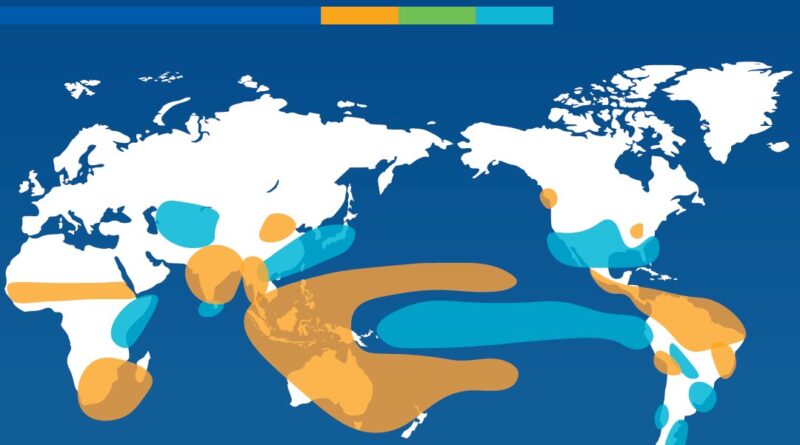
How El Niño Flips the World’s Rainfall Map

Every few years, the Pacific reshuffles the world’s rainfall. Some regions flood. Others dry out. A WMO map tracks exactly where El Niño and La Niña shift precipitation patterns season by season — and right now El Niño is back and potentially heading toward record strength.

Read more: How El Niño Flips the World’s Rainfall Map →
Mapped: Where does Central Europe begin and end?
Political maps
June 15, 2026 Alex

Where Does Central Europe Begin and End? A Heatmap of 16 Definitions

Ask ten geographers where Central Europe ends, and you may get ten different answers. This map combines 16 definitions into a single heatmap and shows which countries are almost always included.

Read more: Where Does Central Europe Begin and End? A Heatmap of 16 Definitions →
Regions of Europe with 1 million people or more
Demography
June 13, 2026 Alex

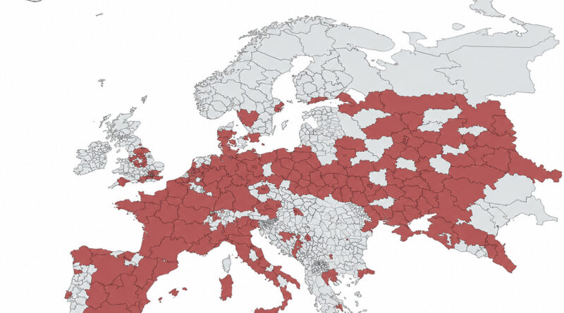
Europe’s Most Populated Regions

Paris, Milan and a curved arc from England to northern Italy account for a disproportionate share of Europe’s population.

Read more: Europe’s Most Populated Regions →
Largest ethnic groups in the world
Ethnic mapsWorld
June 12, 2026 Alex

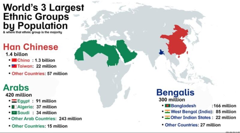
The World’s Three Largest Ethnic Groups and Where They Live

Three ethnic groups account for more than a quarter of everyone alive today.

Read more: The World’s Three Largest Ethnic Groups and Where They Live →
The Price of Happiness by Country Mapped
Economic maps
June 6, 2026 Alex

The Price of Happiness by Country

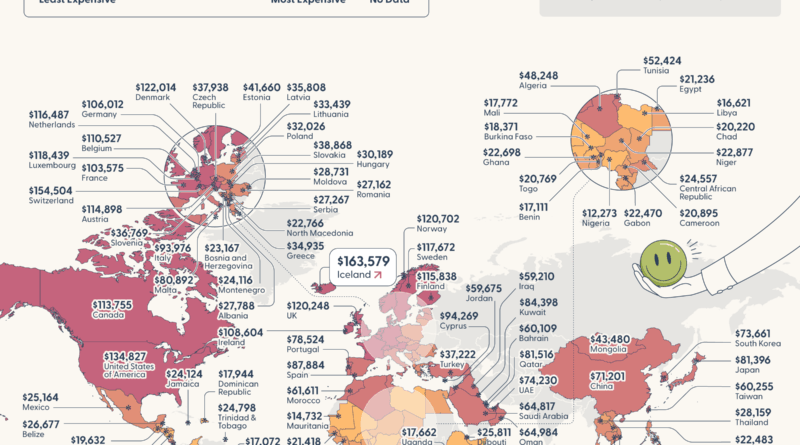
Researchers at Purdue University found there’s a specific income level where more money stops improving how you feel about your life. That threshold is very different depending on where you live: $163,579 in Iceland, $134,827 across the U.S., and just $10,176 in Ethiopia. Only one country’s average wages actually cover the cost.

Read more: The Price of Happiness by Country →
Page 2 of 521«123456789...»Last »

Trending now

  • Human races of the 19th century
    How Has Our View of Human Diversity Changed Since the 19th Century?Oct 22, 2017
  • Spread of the industrial revolution in Europe
    Spread of the Industrial RevolutionSep 11, 2021
  • The “How do I…” question each U.S. state googles more than any other stateJan 28, 2017

Related Products

  • Push pin maps
  • Globe drinks cabinets
  • Maps of the United States
  • Board games
  • Monopoly
  • Map-based strategy board games
  • History Board Games
  • Coloring Books
  • Handheld GPS
  • GPS Watches
  • GPS Trackers

Vivid Maps Tools

  • Convert Latitude/Longitude
  • Elevation Finder
  • Distance Calculator
  • Kilometers to Miles Distance & Length Converter
  • Weight Converter
  • Volume Converter
  • Daylight Comparison
  • Time Zone Converter
  • Antipodes Map
  • Find cities with a similar climate
  • Find cities with a similar climate (2050)
  • How hot cities could be in 2050
  • The U.S. Population Lines

Stay connected

Get the latest maps, insights and updates delivered to your inbox.

Unsubscribe anytime.

VividMaps

Maps that explain the world.

Beautiful, data-rich maps to help you understand our world — its people, places and connections.

Explore

World map World atlas Map posters Globes

Company

About Privacy Contact

Stay connected

Follow us for the latest maps, insights and updates.

Independent WebsiteVirusScanner trust report for vividmaps.com
© 2026 Vivid Maps. All rights reserved.
A more connected world