Job

The Freelancer Pay Gap by U.S. State

In the United States, the population of full-time freelancers surged by 91%, while occasional freelancers saw a staggering increase of 132% between 2020 and 2023. Presently, approximately 72.1 million Americans—comprising roughly 45% of the workforce—engage in freelance work either part-time or as their primary occupation, as reported by MBO Partners. Many individuals have reshaped their career trajectories in response to shifting circumstances or expectations brought on by the pandemic, while others have seamlessly integrated into a landscape where freelancing represents a natural evolution.

Read more: The Freelancer Pay Gap by U.S. State
NewsPhysical mapsVivid maps

Countries that lie on the Equator and Countries that lie on the Prime Meridian

The equator and the prime meridian are two significant lines of latitude and longitude that intersect the Earth, dividing it into the Northern and Southern Hemispheres, and the Eastern and Western Hemispheres, respectively. Countries that lie on the equator experience a tropical climate and have unique flora and fauna. These countries often face challenges such as high temperatures, humidity, and rainfall, but they also boast rich biodiversity and natural resources.

Read more: Countries that lie on the Equator and Countries that lie on the Prime Meridian
Fictional Maps

World Map in George Orwell’s 1984: A Dystopian Geography

George Orwell’s “1984” presents a chilling vision of a world divided into three superstates: Oceania, Eurasia, and Eastasia. This dystopian world map reflects Cold War anxieties and serves as a warning about the dangers of totalitarianism. Discover how Orwell’s fictional geography continues to influence our understanding of power and control in the modern world.

Read more: World Map in George Orwell’s 1984: A Dystopian Geography
World

European Beaver Comeback: Mapping a Century of Population Recovery (1900-2021)

Once nearly extinct across Europe, beavers have made a remarkable comeback over the past century. This post examines the geographic spread of both native Eurasian beavers and introduced North American beavers through compelling map visualizations, highlighting one of wildlife conservation’s greatest success stories alongside its complex ecological implications.

Read more: European Beaver Comeback: Mapping a Century of Population Recovery (1900-2021)
Languages

Etymological Map of America

America’s rich tapestry of stories is woven into the fabric of its landscape, with many tales embedded in the place names of the cities and states. Understanding the meanings behind these names offers insights into the development of the land, its history, and its culture over the centuries. Not only does this deepen our appreciation of our surroundings, but it also enriches our vocabulary and occasionally aids in solving crossword puzzles, a sentiment strongly endorsed by WordTips.

Read more: Etymological Map of America
Historical MapsPolitical maps

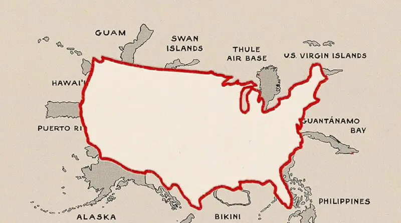
Mapping the Greater United States: How Territories Shaped the Nation

Mapping the Greater United States takes you on a journey beyond the familiar 50 states. With insights from Daniel Immerwahr’s How to Hide an Empire, this post reveals the fascinating history and current status of U.S. territories and former territories that gained independence. Read on for a deeper look into how these regions continue to influence the nation.

Read more: Mapping the Greater United States: How Territories Shaped the Nation