
Skip to content
VividMaps

  • Atlases
  • Map Posters
  • Scratch Maps
  • Globes
  • Videos
EnergyWorld
February 10, 2016 Alex

Annual sunshine hours map of the World

Read more: Annual sunshine hours map of the World →
Building
February 10, 2016 Alex

Paris Buildings Through Time: A Historical Map Story

A fascinating look at Paris’s architectural timeline through detailed map visualizations, showcasing the city’s growth from ancient times to modern day.

Read more: Paris Buildings Through Time: A Historical Map Story →
Interactive mapsInternetLawsMapping StereotypesNatural disastersTerrorismWorld
February 10, 2016 Alex

Natural Disaster Risk 2015

A natural disaster is a major adverse event resulting from natural processes of the Earth; examples include floods, volcanic eruptions,

Read more: Natural Disaster Risk 2015 →
Animated chartsChartsDemographyForecastsPopulation
February 9, 2016 Alex

Population structure of Italy during the 1960-2060 period

Related posts: – Population structure of Turkey during the 1960-2060 period – Population projection (1960 – 2060)  – Population structure

Read more: Population structure of Italy during the 1960-2060 period →
Animated chartsChartsDemographyForecastsGermanyMappingMapping StereotypesPopulation
February 9, 2016 Alex

Population structure of Germany during the 1960-2060 period

Related posts: – Population structure of Turkey during the 1960-2060 period – Population projection (1960 – 2060) – Population structure

Read more: Population structure of Germany during the 1960-2060 period →
Languages
February 9, 2016 Alex

Languages spoken in the Americas

Read more: Languages spoken in the Americas →
CulinaryMapping StereotypesPopulation
February 9, 2016 Alex

The great american burger chain map

Read more: The great american burger chain map →
LanguagesMapping
February 9, 2016 Alex

Places! – Find geospatial patterns in place names

The relative density of patterns in place names. Circle size: weighted by number of places. Via http://bgrsquared.com/places/ Relates posts: – Place Names

Read more: Places! – Find geospatial patterns in place names →
Animated mapsEconomic mapsInteractive maps
February 9, 2016 Alex

When do Americans leave for work?

The map above shows when people leave home for work. The rates are for people who have jobs and are

Read more: When do Americans leave for work? →
CartogramsEconomic mapsSliderWorld
February 9, 2016 Alex

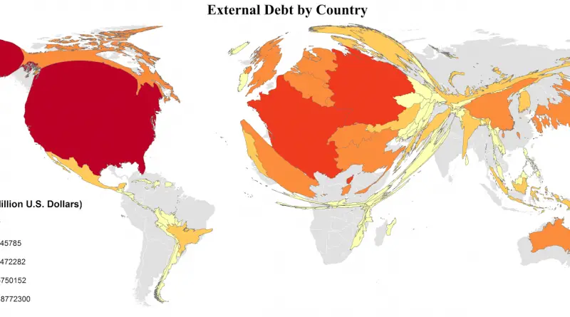
External Debt

External Debt by country External Debt by country per capita   Country Debt per capita, $ Debt m $ Luxembourg

Read more: External Debt →
Mapping HealthMapping Stereotypes
February 8, 2016 Alex

Risk of local Zika transmission

About 30 million people fly to the United States each year from countries in the Caribbean and Latin America that

Read more: Risk of local Zika transmission →
DemographySliderVivid maps
February 8, 2016 Alex

Leading minority group by U.S. county

Leading minority group by county Leading minority group, Ages 0-4, by county Leading minority group, Ages 85+, by county Related

Read more: Leading minority group by U.S. county →
3D mapsDemographyEthnic mapsVivid maps
February 8, 2016 Alex

Leading group by U.S. county

Leading group by county Leading group, Ages 0-4, by county   Leading group, Ages 85+, by county Related posts: –

Read more: Leading group by U.S. county →
Page 343 of 521« First«...339340341342343344345346347...»Last »

Trending now

  • Steel production in 1800 mapped
    220 Years of Steel Production, Mapped From 1800 to 2025Oct 18, 2026
  • Best Value Mobile Data World Map
    Maps reveal what countries have the most affordable mobile dataAug 9, 2021
  • Stereotypes about the United States
    The stereotype map of every US StateOct 29, 2015

Related Products

  • Push pin maps
  • Globe drinks cabinets
  • Maps of the United States
  • Board games
  • Monopoly
  • Map-based strategy board games
  • History Board Games
  • Coloring Books
  • Handheld GPS
  • GPS Watches
  • GPS Trackers

Vivid Maps Tools

  • Convert Latitude/Longitude
  • Elevation Finder
  • Distance Calculator
  • Kilometers to Miles Distance & Length Converter
  • Weight Converter
  • Volume Converter
  • Daylight Comparison
  • Time Zone Converter
  • Antipodes Map
  • Find cities with a similar climate
  • Find cities with a similar climate (2050)
  • How hot cities could be in 2050
  • The U.S. Population Lines

Stay connected

Get the latest maps, insights and updates delivered to your inbox.

Unsubscribe anytime.

VividMaps

Maps that explain the world.

Beautiful, data-rich maps to help you understand our world — its people, places and connections.

Explore

World map World atlas Map posters Globes

Company

About Privacy Contact

Stay connected

Follow us for the latest maps, insights and updates.

Independent WebsiteVirusScanner trust report for vividmaps.com
© 2026 Vivid Maps. All rights reserved.
A more connected world