
Skip to content
VividMaps

  • Atlases
  • Map Posters
  • Scratch Maps
  • Globes
  • Videos
ForecastsNewsPopulation
September 8, 2015 Alex

Projected change in population between today and 2080

Read more: Projected change in population between today and 2080 →
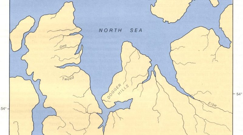
Doggerland mapped
Paleontology
September 8, 2015 Alex

Doggerland: The Lost Land Where You Could Walk from Britain to Europe

Ten thousand years ago, you could walk from Yorkshire to Denmark. Doggerland was a real place with forests, rivers, and people. Now it’s 20 meters underwater in the North Sea.

Read more: Doggerland: The Lost Land Where You Could Walk from Britain to Europe →
Interactive mapsInternet
September 8, 2015 Alex

Mapping the World’s friendships

Rankings between countries are based on the number of Facebook friendships between countries and the total number of Facebook friendships

Read more: Mapping the World’s friendships →
ClimateInteractive mapsNature
September 8, 2015 Alex

Fall foliage prediction map

The 2015 Fall Foliage Map is the ultimate visual planning guide to the annual progressive changing of the leaves. While

Read more: Fall foliage prediction map →
Mapping StereotypesPopulationVideo
September 8, 2015 Alex

50% of the population lives in 148 districts

Read more: 50% of the population lives in 148 districts →
LanguagesMapping StereotypesVideo
September 8, 2015 Alex

Language Distribution in Switzerland

Read more: Language Distribution in Switzerland →
ImmigrationInfographicsMigration maps
September 7, 2015 Alex

Migrants emergency response

366,402 people have arrived in Europe across sea (in 2015) – half of them from Syria.

Read more: Migrants emergency response →
Mapping StereotypesMigration mapsVideo
September 7, 2015 Alex

Migration within Africa and neighbouring regions

Read more: Migration within Africa and neighbouring regions →
DemographyWorld
September 7, 2015 Alex

Intentional homicides per 100,000 people

Read more: Intentional homicides per 100,000 people →
CitiesMapping StereotypesPopulationVideo
September 7, 2015 Alex

How Many U.S. Cities Can You Fit Inside Tokyo?

Each region is labeled with a U.S. city of similar population.

Read more: How Many U.S. Cities Can You Fit Inside Tokyo? →
CulinaryCultural cartographyMapping Stereotypes
September 7, 2015 Alex

Europe Through Italian Taste Buds: A Humorous Food Map

From ‘Real Food’ to ‘Culinary Despair,’ this entertaining map shows how Italians humorously view European cuisines. Cross the Overcooked Pasta Meridian at your own risk!

Read more: Europe Through Italian Taste Buds: A Humorous Food Map →
Historical MapsInfographicsMapping StereotypesVideo
September 7, 2015 Alex

Peoples of the Soviet Union

Read more: Peoples of the Soviet Union →
ImmigrationMigration maps
September 6, 2015 Alex

Seeking a fair distribution of refugees in Europe

The chart below shows that, of the larger countries with stronger economies, Germany and Sweden have accepted many more asylum

Read more: Seeking a fair distribution of refugees in Europe →
Page 432 of 521« First«...428429430431432433434435436...»Last »

Trending now

  • Human races of the 19th century
    How Has Our View of Human Diversity Changed Since the 19th Century?Oct 22, 2017
  • Maps of differences between East and West Germany
    Germany is still divided by east and westSep 11, 2020
  • Most popular social network
    Most Popular Social App by U.S. StateAug 9, 2019

Related Products

  • Push pin maps
  • Globe drinks cabinets
  • Maps of the United States
  • Board games
  • Monopoly
  • Map-based strategy board games
  • History Board Games
  • Coloring Books
  • Handheld GPS
  • GPS Watches
  • GPS Trackers

Vivid Maps Tools

  • Convert Latitude/Longitude
  • Elevation Finder
  • Distance Calculator
  • Kilometers to Miles Distance & Length Converter
  • Weight Converter
  • Volume Converter
  • Daylight Comparison
  • Time Zone Converter
  • Antipodes Map
  • Find cities with a similar climate
  • Find cities with a similar climate (2050)
  • How hot cities could be in 2050
  • The U.S. Population Lines

Stay connected

Get the latest maps, insights and updates delivered to your inbox.

Unsubscribe anytime.

VividMaps

Maps that explain the world.

Beautiful, data-rich maps to help you understand our world — its people, places and connections.

Explore

World map World atlas Map posters Globes

Company

About Privacy Contact

Stay connected

Follow us for the latest maps, insights and updates.

Independent WebsiteVirusScanner trust report for vividmaps.com
© 2026 Vivid Maps. All rights reserved.
A more connected world