Skip to content
Vivid Maps Logo

  • Atlases
  • Map Posters
  • Scratch Maps
  • Globes
  • Videos
Mapped Wheat Maize and Rice production
AgricultureNewsVivid maps

Wheat, Maize, and Rice: Mapping the Crops That Feed the World

August 15, 2025 Alex
World map of countries based on share of immigrants
DemographyNewsVivid maps

Mapped: Countries With the Lowest Percentage of Immigrants

June 18, 2025 Alex
United States border elevation maped
Environment mapsNewsPolitical mapsVivid maps

United States Border Walls

May 21, 2025 Alex
Mapped Wheat Maize and Rice production
AgricultureNewsVivid maps

Wheat, Maize, and Rice: Mapping the Crops That Feed the World

August 15, 2025 Alex
Mapped: Long-Term Orientation in World Cultures
Cultural cartography

Long-Term Orientation in World Cultures

August 10, 2025 Alex
Mapped: Which Countries Get the Most Paid Time Off Overall
Economic mapsJob

How Paid Vacation Varies Around the World

August 5, 2025 Alex
Countries wealthier than the global average mapped
Economic maps

Which Countries Are Wealthier Than the Global Average?

July 27, 2025 Alex
Medeival trade routes
Historical Maps
May 19, 2018 Alex

Medieval Trade Networks

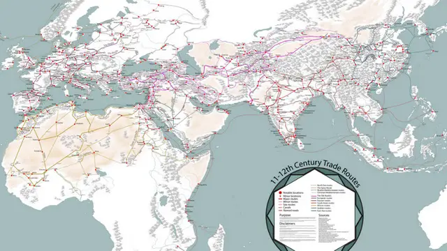
Medieval trade networks were a crucial aspect of the global economy during the Middle Ages, connecting different regions of the

Read More
Old maps
May 19, 2018 Alex

“Chart of part of the South Sea” (1770): A Landmark in Pacific Ocean Mapping

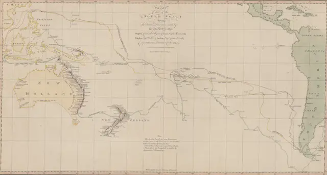
Step into the world of 18th-century exploration with this revolutionary 1770 chart of the South Sea – the first published map to show Australia’s eastern coastline and New Zealand’s complete outline. Created during Captain Cook’s first voyage, this remarkable document changed our understanding of the Pacific Ocean forever.

Read More
A map made in 1500s Jerusalem
Old maps
May 18, 2018 Alex

The Bünting Cloverleaf Map: When Jerusalem Was the Center of the World

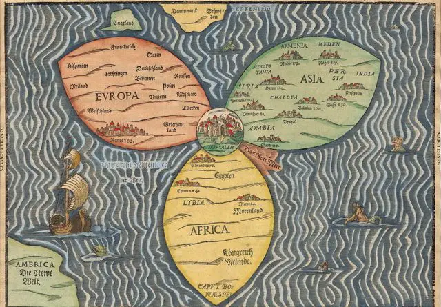
In the late 16th century, German theologian Heinrich Bünting created an extraordinary map that reimagined the world as a three-leaf clover with Jerusalem at its heart. This unusual map tells us much about how people viewed the world through a religious lens during the Renaissance period.

Read More
Farms in Europe
Agriculture
May 16, 2018 Alex

The Geography of Pig Farming: Mapping Europe’s Major Production Regions

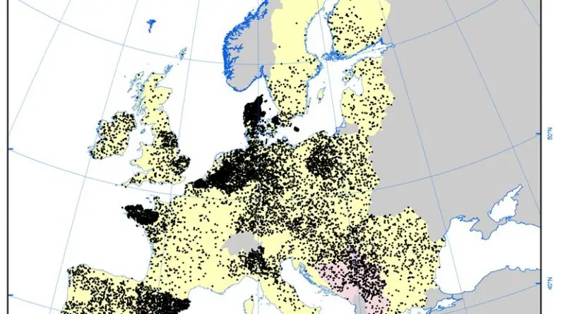
From Brittany to Catalonia, pig farming remains a crucial part of Europe’s agricultural economy. See which regions lead this important industry.

Read More
Size of Texas
Economic mapsSize comparison maps
May 15, 2018 Alex

How Big Is Texas?

The story of Texas’s size is as fascinating as its history. Journey with us through time to understand how this massive territory transformed from a colonial possession to one of America’s largest and most powerful states.

Read More
Cities with a population of 100k by U.S. state
Cities
May 15, 2018 Alex

How Many Cities with a Population of 100k+ does Each U.S. State Have?

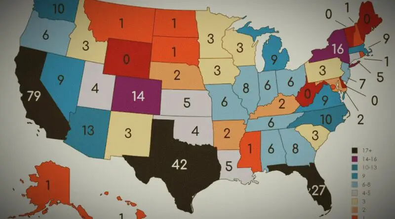
Have you ever wondered how many large cities are in each U.S. state? From the bustling metropolises of California to the smaller yet significant urban centers scattered across the country, the distribution of cities with a population of over 100,000 can reveal interesting insights into the demographic landscape of the United States.

Read More
Old maps
May 14, 2018 Alex

Three Faces of Europe

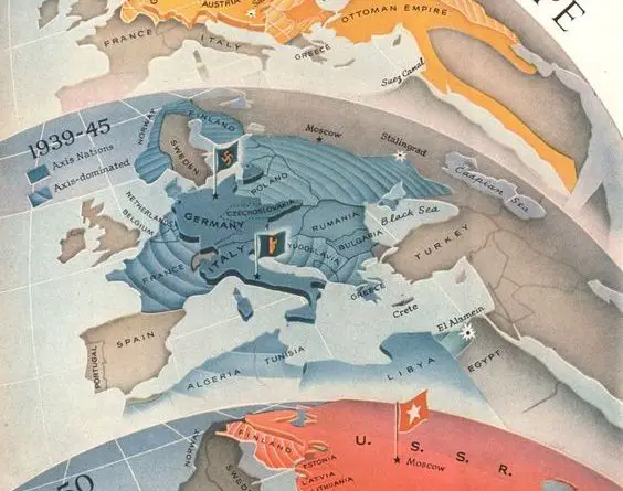
Discover how Europe’s power dynamics shifted through three major conflicts in this rare Time Magazine propaganda map series from WWI to the Cold War.

Read More
Beer Consumption Per Capita United States map
Food
May 13, 2018 Alex

Brewing Across America: A Deeper Look at Beer Consumption and Culture

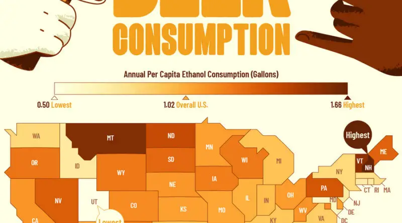
Dive into a comprehensive journey through American beer culture, from state-by-state consumption patterns to the evolving landscape of brewing, revealing surprising insights into how and why Americans drink beer.

Read More
Cities which have historically been claimed to be Britain's 2nd City
Historical Maps
May 11, 2018 Alex

The Contested Crown: Britain’s Ever-Changing Second City

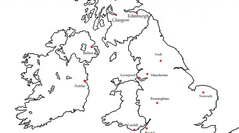
From industrial giants to imperial centers, discover the remarkable cities that have competed for the prestigious “Second City” status throughout British history.

Read More
Most roundest countries
Size comparison maps
May 11, 2018 Alex

The Geometry of Nations: Discovering the World’s Roundest Countries

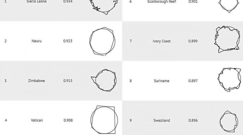
A quirky geographic investigation reveals the most circular nations on Earth, blending mathematics, geography, and unexpected global trivia.

Read More
Page 97 of 673« First«...102030...9596979899...110120130...»Last »

Trending now

  • Map of relief of Europe
    Raised-Relief Maps of Europe
  • Mapped Wheat Maize and Rice production
    Wheat, Maize, and Rice: Mapping the Crops That Feed the World

Related Products

Push pin maps · Globe drinks cabinets · Maps of the United States · Board games · Monopoly · Map-based strategy board games · History Board Games · Coloring Books · Handheld GPS · GPS Watches · GPS Trackers

Vivid Maps Tools

· Convert Latitude/Longitude
· Elevation Finder
· Distance Calculator
· Kilometers to Miles Converter
· Kilograms to Pounds Converter
· Liters to Gallons Converter
· Temperature Converter
· Find cities with a similar climate
· Find cities with a similar climate (2050)
· How hot cities could be in 2050
· The U.S. Population Lines

About
Privacy Policy

Copyright © 2025 Vivid Maps. All rights reserved.