Skip to content
VividMaps

  • Atlases
  • Map Posters
  • Scratch Maps
  • Globes
  • Videos
GoogleMapping Stereotypes
October 3, 2016 Alex

Uninsured rate by U.S. County (2008 – 2014)

Percent with no health insurance by county (2008 – 2014) Related posts: – Uninsured rate by U.S. State (2008 –

Read more: Uninsured rate by U.S. County (2008 – 2014) →

FoodMapping Health
October 3, 2016 Alex

Number of vegetarian restaurants per 1 million inhabitants

Via jakubmarian.com

Read more: Number of vegetarian restaurants per 1 million inhabitants →
Historical MapsMetro mapsSubwayVideoVivid maps
October 3, 2016 Alex

Primary source of food for the various Native North American tribes in the pre-Columbian era (agriculture, hunting, fishing, hunting-gathering)
Related posts: – Historical Map of Native American Tribes in the Continental United States – The native tribes of North

Read more: Primary source of food for the various Native North American tribes in the pre-Columbian era (agriculture, hunting, fishing, hunting-gathering) →
Economic mapsSliderWorld
October 3, 2016 Alex

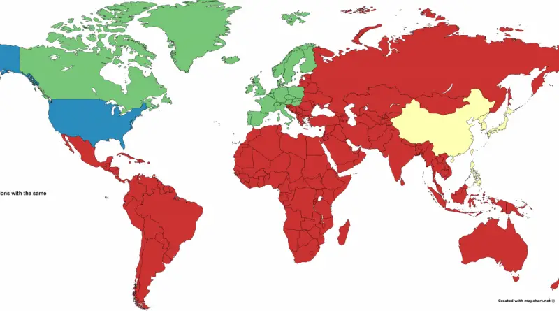
Four regions with the same GDP

Related posts: – US’ individual GDPs compared to countries around the world (2015)  – Comparison between US states and countries

Read more: Four regions with the same GDP →
AnimalsInteractive mapsMapping Stereotypes
October 3, 2016 Alex

Mammal species at rick by country

This map shows Mammal Species at Risk by Country. Mammals include the largest animals on the planet, the great whales,

Read more: Mammal species at rick by country →
EUMapping StereotypesMaps of World ReligionsTerrorism
October 2, 2016 Alex

Weekly religious attendance in the European Union

Read more: Weekly religious attendance in the European Union →
Population
October 2, 2016 Alex

How United States population fits into India

Related posts: – Population distribution of India in USA`s – Indian states and territories populations compared to countries around the

Read more: How United States population fits into India →
LawsMapping StereotypesSubwayVideoWorld
October 2, 2016 Alex

Atlas of long distance relationship

Interesting facts: – The longest clocked in at 44 years, but there were five relationships reported over 30 years and at

Read more: Atlas of long distance relationship →
Energy
October 2, 2016 Alex

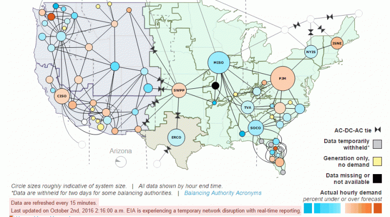
United States electric system operatin data

Source: www.eia.gov

Read more: United States electric system operatin data →
Mapping StereotypesMaps of World ReligionsWorld
October 1, 2016 Alex

Percentage of people who attend weekly religious service

Read more: Percentage of people who attend weekly religious service →
Economic maps
October 1, 2016 Alex

Each province (territory) Biggest Import Trading Partner

Read more: Each province (territory) Biggest Import Trading Partner →
Economic mapsEnvironment mapsMapping Stereotypes
October 1, 2016 Alex

Each State’s Biggest export and import Trading Partner

Read more: Each State’s Biggest export and import Trading Partner →
CitiesMapping StereotypesPopulationWorld
September 30, 2016 Alex

World population divided into 4 regions with the same population

Related post: – World divided into regions with approximately the same population

Read more: World population divided into 4 regions with the same population →
Page 233 of 521« First«...229230231232233234235236237...»Last »

Trending now

  • Steel production in 1800 mapped
    220 Years of Steel Production, Mapped From 1800 to 2025Oct 18, 2026
  • World Map of the Most Uniquely Popular Word On Every County's Wikipedia Page
    The Most Uniquely Popular Word on Each Country’s Wikipedia Page MappedDec 1, 2022
  • Soviet detailed map
    Detailed Cold War-era Soviet military map of the San Francisco Bay area (1980)Oct 22, 2017

Related Products

  • Push pin maps
  • Globe drinks cabinets
  • Maps of the United States
  • Board games
  • Monopoly
  • Map-based strategy board games
  • History Board Games
  • Coloring Books
  • Handheld GPS
  • GPS Watches
  • GPS Trackers

Vivid Maps Tools

  • Convert Latitude/Longitude
  • Elevation Finder
  • Distance Calculator
  • Kilometers to Miles Distance & Length Converter
  • Weight Converter
  • Volume Converter
  • Daylight Comparison
  • Time Zone Converter
  • Antipodes Map
  • Find cities with a similar climate
  • Find cities with a similar climate (2050)
  • How hot cities could be in 2050
  • The U.S. Population Lines

Stay connected

Get the latest maps, insights and updates delivered to your inbox.

Unsubscribe anytime.

VividMaps

Maps that explain the world.

Beautiful, data-rich maps to help you understand our world — its people, places and connections.

Explore

World map World atlas Map posters Globes

Company

About Privacy Contact

Stay connected

Follow us for the latest maps, insights and updates.

Independent WebsiteVirusScanner trust report for vividmaps.com
© 2026 Vivid Maps. All rights reserved.
A more connected world