Skip to content
VividMaps

  • Atlases
  • Map Posters
  • Scratch Maps
  • Globes
  • Videos
BusinessPopulation
October 12, 2016 Alex

“The Hole”, an area of the U.S. northern plains with the population density of Alaska or Mongolia

“The Hole” is home to around 35600 people across 22000 square miles (about the size of Tasmania or Croatia). For

Read more: “The Hole”, an area of the U.S. northern plains with the population density of Alaska or Mongolia →
Job
October 12, 2016 Alex

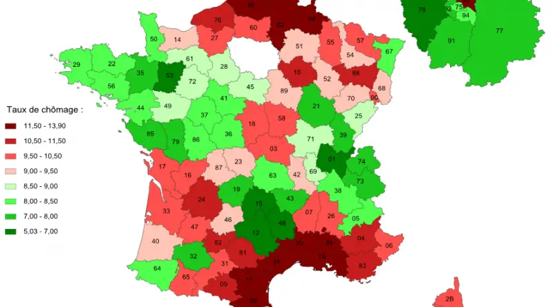
Unemployment by region in France

Read more: Unemployment by region in France →
AgricultureJobNatureSliderWorld
October 12, 2016 Alex

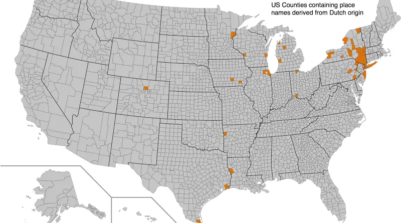
United States counties containing place names derived from Dutch origin

Read more: United States counties containing place names derived from Dutch origin →
BusinessInteractive mapsMap ProjectionsNews
October 12, 2016 Alex

Mapping the Boston Globe

Mapping the Globe is a set of interactive visualizations and maps that help us understand where the Boston Globe directs

Read more: Mapping the Boston Globe →
HurricanesInteractive mapsSliderWorld
October 12, 2016 Alex

Historical Hurricane Tracks (1842 – 2016)

Mapped more than 6000 Hurricanes, ranging from 1842 and occurring in over seven major ocean basins around the world. Related

Read more: Historical Hurricane Tracks (1842 – 2016) →
ChartsEnvironment mapsReal estateSlider
October 11, 2016 Alex

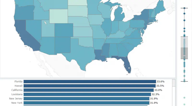
What % of households income is spent on rent in each state?

Read more: What % of households income is spent on rent in each state? →
BusinessEconomic mapsInternetMapping StereotypesWorld
October 11, 2016 Alex

Countries grouped by United Nations

The maps below split all countries into four distinct categories: least developed countries, developing countries, economies in transition and developed

Read more: Countries grouped by United Nations →
LanguagesLawsMapping StereotypesVideo
October 11, 2016 Alex

50% of the World’s languages are located in countries donated in red. In blue are areas of great linguistic diversity.

Read more: 50% of the World’s languages are located in countries donated in red. In blue are areas of great linguistic diversity. →
Economic mapsHistorical Maps
October 11, 2016 Alex

GDP per Capita Europe 1840, 1913, 1938 and 2013

Read more: GDP per Capita Europe 1840, 1913, 1938 and 2013 →
Environment mapsPolitical mapsSlider
October 10, 2016 Alex

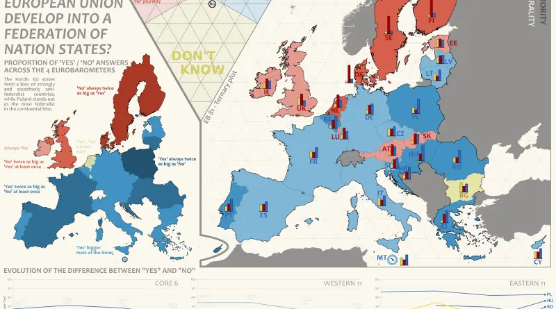
Federalist sentiment within the European Union

– The Nordic EU states form a bloc of strongly and steadfastly antifederalist countries, while Poland and Hungary stands out

Read more: Federalist sentiment within the European Union →
Maps of World Religions
October 10, 2016 Alex

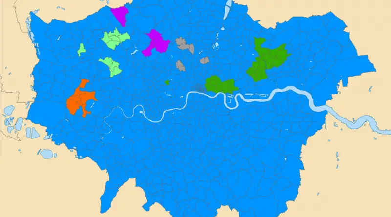
Maps of London by Religion

Historically, London has been primarily Christian. This is evident in many churches around the area, particularly in the City of London, which has around 50 churches. Islam is London’s second-largest denomination. Muslims account for just over 12.4% of London’s population. According to the 2011 Census, 1,012,823 Muslims live in Greater London.

Read more: Maps of London by Religion →
Historical MapsVideo
October 10, 2016 Alex

Rise and Fall of the Tibetan Empire (618 – 842)

In the early 600s a new regional state was formed in the Lhasa region and ousted the old Yarlung Dynasty

Read more: Rise and Fall of the Tibetan Empire (618 – 842) →
World
October 10, 2016 Alex

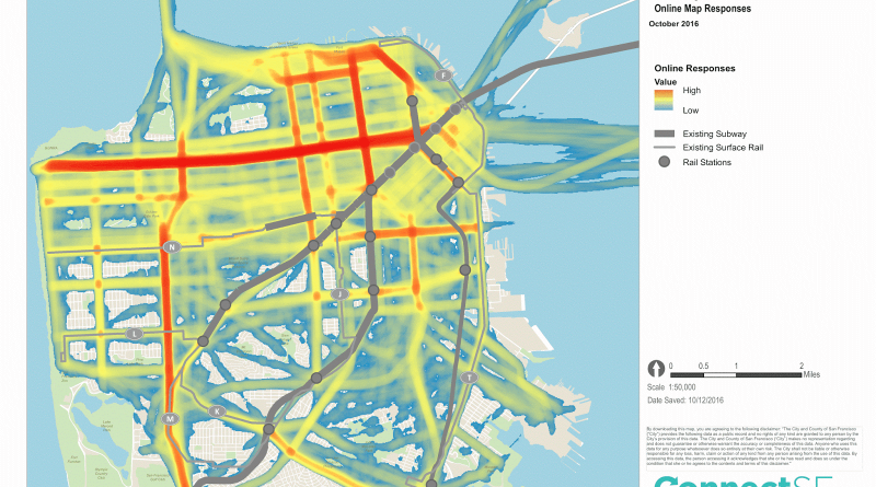
Heat map of 2,600 online responses from an online tool asking people to draw where they think new subway lines should be built in San Francisco

Via connectsf.org Related posts: – On and Off the street grid: relative distributions of road orientations – Mapping female versus

Read more: Heat map of 2,600 online responses from an online tool asking people to draw where they think new subway lines should be built in San Francisco →
Page 229 of 521« First«...225226227228229230231232233...»Last »

Trending now

  • Soviet detailed map
    Detailed Cold War-era Soviet military map of the San Francisco Bay area (1980)Oct 22, 2017
  • World Map of the Most Uniquely Popular Word On Every County's Wikipedia Page
    The Most Uniquely Popular Word on Each Country’s Wikipedia Page MappedDec 1, 2022
  • Language Families Spoken in AfricaOct 21, 2017

Related Products

  • Push pin maps
  • Globe drinks cabinets
  • Maps of the United States
  • Board games
  • Monopoly
  • Map-based strategy board games
  • History Board Games
  • Coloring Books
  • Handheld GPS
  • GPS Watches
  • GPS Trackers

Vivid Maps Tools

  • Convert Latitude/Longitude
  • Elevation Finder
  • Distance Calculator
  • Kilometers to Miles Distance & Length Converter
  • Weight Converter
  • Volume Converter
  • Daylight Comparison
  • Time Zone Converter
  • Antipodes Map
  • Find cities with a similar climate
  • Find cities with a similar climate (2050)
  • How hot cities could be in 2050
  • The U.S. Population Lines

Stay connected

Get the latest maps, insights and updates delivered to your inbox.

Unsubscribe anytime.

VividMaps

Maps that explain the world.

Beautiful, data-rich maps to help you understand our world — its people, places and connections.

Explore

World map World atlas Map posters Globes

Company

About Privacy Contact

Stay connected

Follow us for the latest maps, insights and updates.

Independent WebsiteVirusScanner trust report for vividmaps.com
© 2026 Vivid Maps. All rights reserved.
A more connected world