
Skip to content
VividMaps

  • Atlases
  • Map Posters
  • Scratch Maps
  • Globes
  • Videos
Real estate
April 21, 2016 Alex

% house price change in England and Wales (2007 vs 2015)

Read more: % house price change in England and Wales (2007 vs 2015) →
EnergyEnvironment mapsMapping Stereotypes
April 21, 2016 Alex

Most prevalent fuel used to heat the home by U.S. Zip code

Read more: Most prevalent fuel used to heat the home by U.S. Zip code →
Environment mapsInteractive mapsInternetMapping StereotypesTransportVivid maps
April 21, 2016 Alex

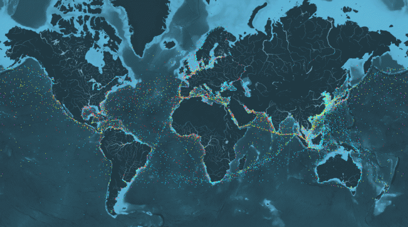
An incredible visualisation of global shipping traffic

What can I see? You can see movements of the global merchant fleet over the course of 2012, overlaid on

Read more: An incredible visualisation of global shipping traffic →
Nature
April 21, 2016 Alex

Where billions of cicadas will emerge this spring & the next decade

For 17 years, cicadas do very little. They hang out in the ground, sucking sugar out of tree roots. Then,

Read more: Where billions of cicadas will emerge this spring & the next decade →
World
April 20, 2016 Alex

Global Power City Index (2015)

Read more: Global Power City Index (2015) →
BuildingMapping StereotypesNatural disasters
April 20, 2016 Alex

Maximum seismic intensity experienced in areas of Japan

Shindo scale, 1-7

Read more: Maximum seismic intensity experienced in areas of Japan →
CitiesInternetLawsMapping StereotypesReal-Time MapsRiversTraffic Map
April 20, 2016 Alex

Rivers that flow through multiple capitals

Related posts: – Elevation of global capitals – Countries whose capital is close to the border – Countries with multiple

Read more: Rivers that flow through multiple capitals →
CitiesEconomic maps
April 20, 2016 Alex

Where is the U.S. GDP concentrated?

According to the Bureau of Economic Analysis data, only 31 U.S. counties made up about 33 percent of U.S. Gross Domestic Product. GDP concentration in the U.S. 81 counties produced 50 percent of the nation’s GDP.

Read more: Where is the U.S. GDP concentrated? →
Historical MapsWars
April 20, 2016 Alex

World War 1 & 2 deaths as a percentage of each nation’s population

World War 1 deaths as a percentage of each nation’s population   World War 2 deaths as a percentage of

Read more: World War 1 & 2 deaths as a percentage of each nation’s population →
Economic maps
April 20, 2016 Alex

Countries by military expenditures

Countries by military expenditures in 2014 (% of GDP) Government Budgets: Education vs Military Spending The ratio between military expenditures

Read more: Countries by military expenditures →
CitiesTransport
April 20, 2016 Alex

A day with no metro in Washington

A Day with No Metro: The Metro system shut down for emergency repairs on March 16, 2016. This map visualizes

Read more: A day with no metro in Washington →
CitiesPolitical maps
April 20, 2016 Alex

How Every New York City Neighborhood Voted in the Democratic and Republican Primary

How every New York City neighborhood voted in the Democratic Primary   How every New York City neighborhood voted in

Read more: How Every New York City Neighborhood Voted in the Democratic and Republican Primary →
AnimalsHistorical Maps
April 20, 2016 Alex

Unification of the British Isles since 800 A.D.

Read more: Unification of the British Isles since 800 A.D. →
Page 306 of 521« First«...302303304305306307308309310...»Last »

Trending now

  • Steel production in 1800 mapped
    220 Years of Steel Production, Mapped From 1800 to 2025Oct 18, 2026
  • Best Value Mobile Data World Map
    Maps reveal what countries have the most affordable mobile dataAug 9, 2021
  • Stereotypes about the United States
    The stereotype map of every US StateOct 29, 2015

Related Products

  • Push pin maps
  • Globe drinks cabinets
  • Maps of the United States
  • Board games
  • Monopoly
  • Map-based strategy board games
  • History Board Games
  • Coloring Books
  • Handheld GPS
  • GPS Watches
  • GPS Trackers

Vivid Maps Tools

  • Convert Latitude/Longitude
  • Elevation Finder
  • Distance Calculator
  • Kilometers to Miles Distance & Length Converter
  • Weight Converter
  • Volume Converter
  • Daylight Comparison
  • Time Zone Converter
  • Antipodes Map
  • Find cities with a similar climate
  • Find cities with a similar climate (2050)
  • How hot cities could be in 2050
  • The U.S. Population Lines

Stay connected

Get the latest maps, insights and updates delivered to your inbox.

Unsubscribe anytime.

VividMaps

Maps that explain the world.

Beautiful, data-rich maps to help you understand our world — its people, places and connections.

Explore

World map World atlas Map posters Globes

Company

About Privacy Contact

Stay connected

Follow us for the latest maps, insights and updates.

Independent WebsiteVirusScanner trust report for vividmaps.com
© 2026 Vivid Maps. All rights reserved.
A more connected world