
Skip to content
VividMaps

  • Atlases
  • Map Posters
  • Scratch Maps
  • Globes
  • Videos
Size comparison maps
April 15, 2016 Alex

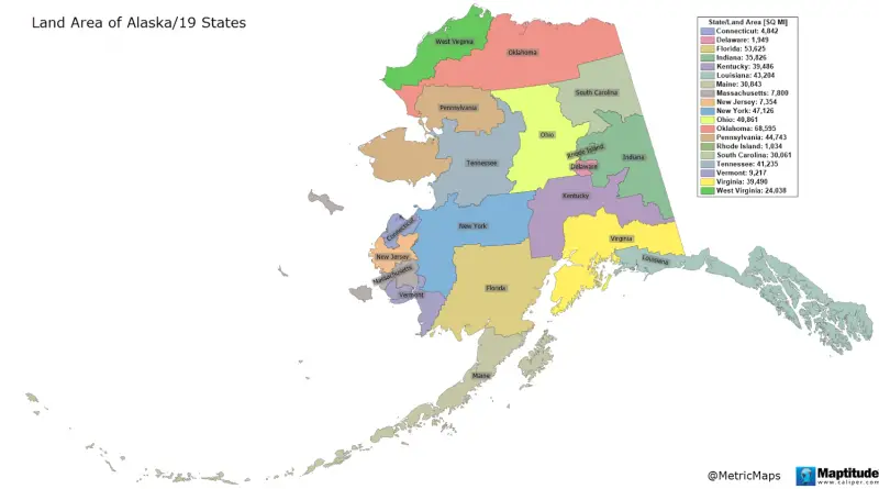
How Big Is Alaska?

Alaska is the biggest U.S. state by area and the 7th-biggest subnational division among all countries. It is the 3rd-least populated and the most sparseness populated U.S. state but by far the continent’s most populous territory, mostly north of the 60th parallel, with an estimated population of approximately 800 thousand.

Read more: How Big Is Alaska? →
Historical Maps
April 15, 2016 Alex

Political maps of Britain

Political map of Britain (878 AD) Britain during the reign of the first king Alfred the Great. Map of Britain

Read more: Political maps of Britain →
GermanyLanguages
April 14, 2016 Alex

Regional greetings in German

Read more: Regional greetings in German →
Interactive mapsMapping StereotypesTransport
April 14, 2016 Alex

Bicycle Stress Map

This map shows the levels of traffic stress that people who bicycle experience on each public road (excluding freeways) and

Read more: Bicycle Stress Map →
Cultural cartographyInteractive mapsIsochrone mapsNatureVideo
April 13, 2016 Alex

A new view of the tree of life

The tree includes 92 named bacterial phyla, 26 archaeal phyla and all five of the Eukaryotic supergroups. Major lineages are

Read more: A new view of the tree of life →
Mapping StereotypesPolitical maps
April 13, 2016 Alex

How Donald Trump sees the world

Huff post Related posts: – The World according to Donald Trump  – The World according to Donald Trump (2016) –

Read more: How Donald Trump sees the world →
Climate ChangeEnvironment mapsImmigrationMapping StereotypesMexico
April 13, 2016 Alex

Map showing the close link between increased economic prosperity & carbon footprints

Read more: Map showing the close link between increased economic prosperity & carbon footprints →
Happiness
April 13, 2016 Alex

Europe’s rural-urban happiness divide

Read more: Europe’s rural-urban happiness divide →
Political maps
April 12, 2016 Alex

Europe and some of its relationships mapped

Europe and its politics are inseparably complicated. The Schengen agreement remains one of the world’s most extensive areas that have ended boundary control among member countries. It comprises 26 European countries that have canceled all border control types at their joint borders.

Read more: Europe and some of its relationships mapped →
Education
April 12, 2016 Alex

Greater Los Angeles: College Educational Attainment

www.clipper.com San Diegle leads state in percentage of residents with bachelor degree.

Read more: Greater Los Angeles: College Educational Attainment →
Crime maps
April 12, 2016 Alex

San Francisco violent crimes, hot spot analysis (2003 – 2015)

Read more: San Francisco violent crimes, hot spot analysis (2003 – 2015) →
Population
April 12, 2016 Alex

A year of population change

Percent change in U.S. resident population 2014 – 2015. Via washingtonpost.com Related posts: – U.S. Population under 5 years of

Read more: A year of population change →
CitiesInteractive mapsMapping Stereotypes
April 12, 2016 Alex

8 U.S. State populations that fit into the 5 New York boroughs

Related posts: – New York City transit frequency – Yellow Taxi Trips (2015)  – TV Shooting Locations in New York

Read more: 8 U.S. State populations that fit into the 5 New York boroughs →
Page 310 of 521« First«...306307308309310311312313314...»Last »

Trending now

  • Steel production in 1800 mapped
    220 Years of Steel Production, Mapped From 1800 to 2025Oct 18, 2026
  • Best Value Mobile Data World Map
    Maps reveal what countries have the most affordable mobile dataAug 9, 2021
  • Stereotypes about the United States
    The stereotype map of every US StateOct 29, 2015

Related Products

  • Push pin maps
  • Globe drinks cabinets
  • Maps of the United States
  • Board games
  • Monopoly
  • Map-based strategy board games
  • History Board Games
  • Coloring Books
  • Handheld GPS
  • GPS Watches
  • GPS Trackers

Vivid Maps Tools

  • Convert Latitude/Longitude
  • Elevation Finder
  • Distance Calculator
  • Kilometers to Miles Distance & Length Converter
  • Weight Converter
  • Volume Converter
  • Daylight Comparison
  • Time Zone Converter
  • Antipodes Map
  • Find cities with a similar climate
  • Find cities with a similar climate (2050)
  • How hot cities could be in 2050
  • The U.S. Population Lines

Stay connected

Get the latest maps, insights and updates delivered to your inbox.

Unsubscribe anytime.

VividMaps

Maps that explain the world.

Beautiful, data-rich maps to help you understand our world — its people, places and connections.

Explore

World map World atlas Map posters Globes

Company

About Privacy Contact

Stay connected

Follow us for the latest maps, insights and updates.

Independent WebsiteVirusScanner trust report for vividmaps.com
© 2026 Vivid Maps. All rights reserved.
A more connected world