Environment maps

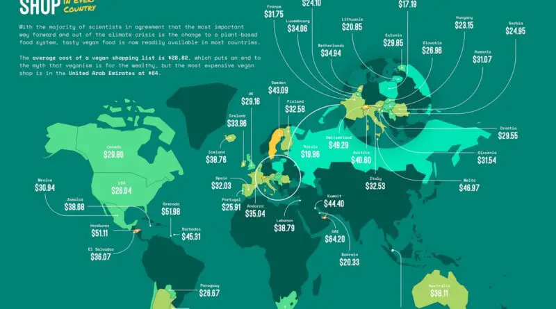
The countries’ borders that are visible from space

At first glance, it might seem that human activity is relatively insignificant compared to high mountain ranges and vast oceans when viewing the globe from space. But if you look closely, human activity has become so all-encompassing that it can be seen on any continent on Earth. The most exciting fact is that even political borders can be discerned from space, as each country has its specific land-use features.

Read More
FoodWorld

The Most Popular Beer Brands In Every State, Mapped

The covid-19 pandemic has induced many shifts inhabits, with the latest numbers proposing our alcohol consumption is one of them. Purchases of alcohol are have risen by 8.92 percent since the pandemic touched the United States. Budweiser is the most prevalent cheap beer across the U.S. by far, listing first in 23 U.S. states. Bud Light takes second place as the preferred beer only in 6 U.S. states.

Read More
AnimalsLaws

Exotic Animal Laws by U.S. State Mapped

Four U.S. states have no law restrictions on keeping dangerous wild animals as pets (Alabama, Nevada, North Carolina, and Wisconsin). Six states regulate having hazardous animals as pets (Alabama, Nevada, North Carolina, Wisconsin, Delaware, and Oklahoma). Twenty-one U.S. states outlaw all dangerous exotic animals, while the rest need permissions. Thirty-five states forbid holding hazardous animals as pets, with differing exceptions and demands.

Read More
Political maps

Children Archipelago

Violence toward children crosses boundaries of geography, race, social status, education, religion, and culture. It happens in homes and streets, schools, orphanages, and other care centers, places of work, and entertainment. Perpetrators include family members, caretakers, teachers, law enforcement officials, and other kids. Some children are especially unsafe because of disability, gender, nationality, ethnic origin, class. And no nation is exempt, whether wealthy or poor.

Read More