
Skip to content
VividMaps

  • Atlases
  • Map Posters
  • Scratch Maps
  • Globes
  • Videos
Political mapsWorld
February 21, 2016 Alex

The election days by country

Read more: The election days by country →
DemographyEthnic mapsInteractive mapsPopulationVivid maps
February 21, 2016 Alex

U.S. White Non-Hispanic Population under 5 years of age Percent Change by County (2010 – 2014)

Related posts: – White Non-Hispanic population percentage by county – U.S. Population under 5 years of age percent change by county

Read more: U.S. White Non-Hispanic Population under 5 years of age Percent Change by County (2010 – 2014) →
Cultural cartographyInteractive mapsWorld
February 20, 2016 Alex

Network Readiness Index

The World Economic Forum’s Networked Readiness Index(NRI), also referred to as Technology Readiness, measures the propensity for countries to exploit

Read more: Network Readiness Index →
BusinessLanguagesMapping Stereotypes
February 20, 2016 Alex

Quotation marks by European country

Read more: Quotation marks by European country →
Map of the United States: Sleep Patterns
Mapping Health
February 20, 2016 Alex

Sleep Patterns Across the USA

nsightful maps of the United States reveal surprising patterns in Americans’ sleep habits. From Colorado’s well-rested population to Hawaii’s unexpected sleep shortage, these visualizations offer a wake-up call about the importance of getting enough shut-eye. Dive into the regional factors influencing our sleep and learn practical tips for improving your own sleep quality.

Read more: Sleep Patterns Across the USA →
Historical MapsOld maps
February 20, 2016 Alex

Relative sizes of the United States and The European Powers (1920)

Read more: Relative sizes of the United States and The European Powers (1920) →
CarsInteractive mapsMapping HealthWorld
February 19, 2016 Alex

Road fatalities per 100,000 motor vehicles

Read more: Road fatalities per 100,000 motor vehicles →
BusinessInternetMapping StereotypesPopulation
February 19, 2016 Alex

94% of the Chinese population lives east of this line

Read more: 94% of the Chinese population lives east of this line →
Animated mapsEthnic mapsHistorical MapsOld maps
February 19, 2016 Alex

A Swiss ethnographic map (1918)

Read more: A Swiss ethnographic map (1918) →
World
February 19, 2016 Alex

5 maps that quantify exactly how rammed London is

London–it’s quite busy, isn’t it? But maybe more than you even think. As of this time last year, 8.6 million

Read more: 5 maps that quantify exactly how rammed London is →
ChartsCitiesInternetLawsMapping StereotypesReal estate
February 19, 2016 Alex

Commuting times and housing costs compared in 8 major cities

Via  ft.com

Read more: Commuting times and housing costs compared in 8 major cities →
Business
February 19, 2016 Alex

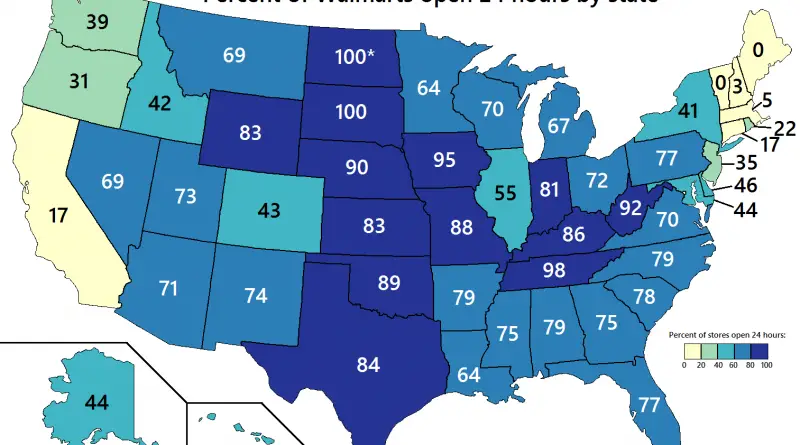
Percent of Walmart stores open 24 hours by US state

Related post: – The explosive growth of Walmart (1962 – 2006)

Read more: Percent of Walmart stores open 24 hours by US state →
DemographyPopulationVivid maps
February 19, 2016 Alex

U.S. Population under 5 years of age percent change by county

Relates posts: – U.S. White Non-Hispanic Population under 5 years of age Percent Change by County (2010 – 2014) –

Read more: U.S. Population under 5 years of age percent change by county →
Page 337 of 521« First«...333334335336337338339340341...»Last »

Trending now

  • Steel production in 1800 mapped
    220 Years of Steel Production, Mapped From 1800 to 2025Oct 18, 2026
  • Best Value Mobile Data World Map
    Maps reveal what countries have the most affordable mobile dataAug 9, 2021
  • Stereotypes about the United States
    The stereotype map of every US StateOct 29, 2015

Related Products

  • Push pin maps
  • Globe drinks cabinets
  • Maps of the United States
  • Board games
  • Monopoly
  • Map-based strategy board games
  • History Board Games
  • Coloring Books
  • Handheld GPS
  • GPS Watches
  • GPS Trackers

Vivid Maps Tools

  • Convert Latitude/Longitude
  • Elevation Finder
  • Distance Calculator
  • Kilometers to Miles Distance & Length Converter
  • Weight Converter
  • Volume Converter
  • Daylight Comparison
  • Time Zone Converter
  • Antipodes Map
  • Find cities with a similar climate
  • Find cities with a similar climate (2050)
  • How hot cities could be in 2050
  • The U.S. Population Lines

Stay connected

Get the latest maps, insights and updates delivered to your inbox.

Unsubscribe anytime.

VividMaps

Maps that explain the world.

Beautiful, data-rich maps to help you understand our world — its people, places and connections.

Explore

World map World atlas Map posters Globes

Company

About Privacy Contact

Stay connected

Follow us for the latest maps, insights and updates.

Independent WebsiteVirusScanner trust report for vividmaps.com
© 2026 Vivid Maps. All rights reserved.
A more connected world