Skip to content
VividMaps

  • Atlases
  • Map Posters
  • Scratch Maps
  • Globes
  • Videos
Interactive mapsMapping StereotypesTerrorism
February 19, 2016 Alex

Terrorism in the U.S. (1970 – 2014)

The map above show terrorist attacks in the United States. Circle sizes signify number of deaths and injuries. The data

Read more: Terrorism in the U.S. (1970 – 2014) →

Historical MapsImmigration
February 19, 2016 Alex

Foreign-born population in Norway (1910)

This map shows the census entry ‘place of birth’ for every person present within Norway on 1 December 1910. The

Read more: Foreign-born population in Norway (1910) →
BusinessEthnic mapsEULanguagesMapping Stereotypes
February 19, 2016 Alex

Knowledge of the French language in the EU

Read more: Knowledge of the French language in the EU →
AgricultureChartsEULanguagesMapping Stereotypes
February 18, 2016 Alex

Knowledge of the German language in the EU

Read more: Knowledge of the German language in the EU →
EULanguages
February 18, 2016 Alex

Who speaks English in the EU?

Read more: Who speaks English in the EU? →
EULanguagesNatureSlider
February 18, 2016 Alex

Who speaks Spanish in the EU?

Read more: Who speaks Spanish in the EU? →
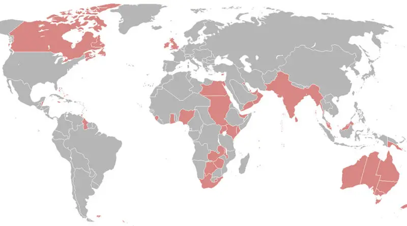
Extent of the British Empire in 1898
Historical Maps
February 18, 2016 Alex

Places named after Queen Victoria

Queen Victoria’s enduring legacy is evident in the numerous place-names around the world that commemorate her. Her reign, marked by significant advancements and expansion, continues to be celebrated and remembered globally.

Read more: Places named after Queen Victoria →
Interactive mapsPolitical maps
February 17, 2016 Alex

Social Progress Index (2015)

The Social Progress Index measures the extent to which countries provide for the social and environmental needs of their citizens.

Read more: Social Progress Index (2015) →
Economic mapsEnvironment mapsPollutionSliderWealthWorld
February 17, 2016 Alex

Wealth per adult in USD by Credit Suisse (2015)

Read more: Wealth per adult in USD by Credit Suisse (2015) →
3D mapsAnimated mapsHistorical MapsImmigrationLidarMapping StereotypesMexicoPolitical maps
February 17, 2016 Alex

Freedom in the World (1985 – 2015)

Read more: Freedom in the World (1985 – 2015) →
Economic mapsInternetMapping StereotypesRivers
February 17, 2016 Alex

USA States Renamed after countries similar GDP (2015)

Read more: USA States Renamed after countries similar GDP (2015) →
3D mapsAgricultureInternetMapping StereotypesNature
February 17, 2016 Alex

World distribution of snakes

Read more: World distribution of snakes →
DemographyEthnic mapsPopulationVivid maps
February 17, 2016 Alex

U.S. Indian American population, percent increase by county

Related posts: – U.S. Indian American Population under 5 years of age Percent Change by County (2010 – 2014) –

Read more: U.S. Indian American population, percent increase by county →
Page 338 of 521« First«...334335336337338339340341342...»Last »

Trending now

  • Steel production in 1800 mapped
    220 Years of Steel Production, Mapped From 1800 to 2025Oct 18, 2026
  • Best Value Mobile Data World Map
    Maps reveal what countries have the most affordable mobile dataAug 9, 2021
  • Stereotypes about the United States
    The stereotype map of every US StateOct 29, 2015

Related Products

  • Push pin maps
  • Globe drinks cabinets
  • Maps of the United States
  • Board games
  • Monopoly
  • Map-based strategy board games
  • History Board Games
  • Coloring Books
  • Handheld GPS
  • GPS Watches
  • GPS Trackers

Vivid Maps Tools

  • Convert Latitude/Longitude
  • Elevation Finder
  • Distance Calculator
  • Kilometers to Miles Distance & Length Converter
  • Weight Converter
  • Volume Converter
  • Daylight Comparison
  • Time Zone Converter
  • Antipodes Map
  • Find cities with a similar climate
  • Find cities with a similar climate (2050)
  • How hot cities could be in 2050
  • The U.S. Population Lines

Stay connected

Get the latest maps, insights and updates delivered to your inbox.

Unsubscribe anytime.

VividMaps

Maps that explain the world.

Beautiful, data-rich maps to help you understand our world — its people, places and connections.

Explore

World map World atlas Map posters Globes

Company

About Privacy Contact

Stay connected

Follow us for the latest maps, insights and updates.

Independent WebsiteVirusScanner trust report for vividmaps.com
© 2026 Vivid Maps. All rights reserved.
A more connected world