Skip to content
Vivid Maps Logo

  • Atlases
  • Map Posters
  • Scratch Maps
  • Globes
  • Videos
Global Coffee Arabica Cultivation Mapped
AgricultureNewsVivid maps

From Highland Peaks to Lowland Valleys: Mapping the World’s Coffee and Tea Territories

August 19, 2025 Alex
Mapped Wheat Maize and Rice production
AgricultureNewsVivid maps

Wheat, Maize, and Rice: Mapping the Crops That Feed the World

August 15, 2025 Alex
World map of countries based on share of immigrants
DemographyNewsVivid maps

Mapped: Countries With the Lowest Percentage of Immigrants

June 18, 2025 Alex
Global Coffee Arabica Cultivation Mapped
AgricultureNewsVivid maps

From Highland Peaks to Lowland Valleys: Mapping the World’s Coffee and Tea Territories

August 19, 2025 Alex
Mapped Wheat Maize and Rice production
AgricultureNewsVivid maps

Wheat, Maize, and Rice: Mapping the Crops That Feed the World

August 15, 2025 Alex
Mapped: Long-Term Orientation in World Cultures
Cultural cartography

Long-Term Orientation in World Cultures

August 10, 2025 Alex
Mapped: Which Countries Get the Most Paid Time Off Overall
Economic mapsJob

How Paid Vacation Varies Around the World

August 5, 2025 Alex
Gastronomic map of Italy, 1962
CulinaryFood
April 15, 2019 Alex

Gastronomic maps of Italy

Italian cuisine is highly regarded and has a global reputation for its diversity, abundance of taste, flavors, and use of fresh ingredients. It has made a significant impact on culinary traditions worldwide and is loved by many. Moreover, it influenced several cuisines around the world.

Read More
the most valuable agricultural commodity in the USA
Agriculture
April 12, 2019 Alex

Mapping the Most Valuable Agricultural Commodity in Each U.S. State

Agriculture is a major industry in the U.S., which is a net exporter of food. In the United States about 2.2 million farms, covering an area of 922 million acres (3,730,000 km2), an average of 418 acres (169 hectares) per farm.

Read More
Mega cities
CitiesForecasts
April 10, 2019 Alex

Mega-urban population in 2025 and 2050

The world of the 21st century is predominantly urban, with currently 54% of the global population residing in cities, and an expected increase to 66% until 2050.

Read More
Map of Tornado Alley
Natural disastersWeather
April 9, 2019 Alex

Tornado activity in the United States mapped

The United States receives more than 1.2 thousand tornadoes yearly (4 times the amount seen in Europe). Damaging tornadoes rated EF4 or EF5 on the Enhanced Fujita Scale happen more frequently in the U.S. than in any other nation. Over 80 deaths and 1,500 injuries in the U.S. are associated with tornadoes each year.

Read More
EnergyEnvironment maps
April 8, 2019 Alex

Coal power generation in Europe

Coal usage in Europe has been undergoing significant changes in recent years due to various factors, including environmental concerns, government policies, and the growing renewable energy sector.

Read More
Political maps
April 7, 2019 Alex

The age of borders: when were the world’s current borders first defined

Borders are geographic boundaries of political entities established through arrangements. 52.2 percent of the world’s borders were set during the 20th century. Most of the world’s borders were formed after World War I.

Read More
The words that traveled with trade
Languages
April 6, 2019 Alex

The Spread of Words Along Trade Routes

Throughout history, trade has been accompanied by what linguists call Wanderwörter – words borrowed from one language to another across vast distances, often along trade routes.

Read More
US water bodies
LanguagesNewsVivid maps
April 1, 2019 Alex

Lake, River, Spring, Pond, Bay and Swamp

The concentrations of water toponyms in the United States.

Read More
People of Arcitic
LanguagesOld maps
March 30, 2019 Alex

Peoples of the Arctic

The Arctic region is home to diverse indigenous peoples who have inhabited the area for thousands of years. These peoples have adapted to the extreme cold, harsh environments, and unique challenges of the Arctic.

Read More
Google Trends Maps
Mapping Stereotypes
March 26, 2019 Alex

Google Trends Maps

The xkcd team created the least informative Google trends maps. According to the team, all maps a real but created

Read More
Page 73 of 673« First«...102030...7172737475...8090100...»Last »

Trending now

  • The Price of Sex around the World Mapped
  • Mapped Wheat Maize and Rice production
    Wheat, Maize, and Rice: Mapping the Crops That Feed the World

Related Products

Push pin maps · Globe drinks cabinets · Maps of the United States · Board games · Monopoly · Map-based strategy board games · History Board Games · Coloring Books · Handheld GPS · GPS Watches · GPS Trackers

Vivid Maps Tools

· Convert Latitude/Longitude
· Elevation Finder
· Distance Calculator
· Kilometers to Miles Converter
· Kilograms to Pounds Converter
· Liters to Gallons Converter
· Temperature Converter
· Find cities with a similar climate
· Find cities with a similar climate (2050)
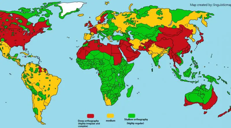
· How hot cities could be in 2050
· The U.S. Population Lines

About
Privacy Policy

Copyright © 2025 Vivid Maps. All rights reserved.