Skip to content
VividMaps

  • Atlases
  • Map Posters
  • Scratch Maps
  • Globes
  • Videos
ChartsCultural cartographyInternetReal estateVideoVivid maps
November 1, 2016 Alex

What U.S. states have households with the largest lot size?

3.32% of U.S. households are on lots of 10 acres or more.

Read more: What U.S. states have households with the largest lot size? →

Old mapsSliderWorld
November 1, 2016 Alex

Moral And Political Chart Of The World (1827)

“Government degree of civilization and number of inhabitants.”

Read more: Moral And Political Chart Of The World (1827) →
Historical MapsImmigrationWars
November 1, 2016 Alex

World War II deaths as a percentage of each nation’s population

Read more: World War II deaths as a percentage of each nation’s population →
DemographyFoodReal estate
November 1, 2016 Alex

Percentage of Milk Which is Ultra Heat Treated in Europe

Related posts: – Milk consumption in liters per year per capita – Percentage of adult population that can drink milk 

Read more: Percentage of Milk Which is Ultra Heat Treated in Europe →
Environment mapsPollutionWorld
November 1, 2016 Alex

Map of Toxic Air

UNICEF

Read more: Map of Toxic Air →
3D mapsLidarMappingScience
November 1, 2016 Alex

San Francisco LIDAR data

Via bl.ocks.org

Read more: San Francisco LIDAR data →
BusinessInteractive mapsJob
November 1, 2016 Alex

Jobs in Boston by industry and wage

Source: www.coaxs.mit.edu/job-map/   Jobs (according to 2014 LEHD data) in the MBTA primary and secondary assessment districts, by industry and

Read more: Jobs in Boston by industry and wage →
3D mapsInteractive mapsReal estate
November 1, 2016 Alex

Jersey city building census

Control: – Click on a building footprint for zone and parcel information. – Use shift + up and down/left and

Read more: Jersey city building census →
Mapping HealthMapping Stereotypes
October 31, 2016 Alex

Medicine prescription by constituency: variation across England between drug categories

Darker shading denotes higher number of items prescribed per head.

Read more: Medicine prescription by constituency: variation across England between drug categories →
World
October 31, 2016 Alex

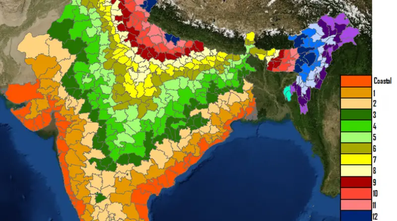
Number of Indian Districts one must travel through to reach the ocean

Read more: Number of Indian Districts one must travel through to reach the ocean →
Mapping Stereotypes
October 31, 2016 Alex

Block Shaped Counties in the Contiguous U.S.

Read more: Block Shaped Counties in the Contiguous U.S. →
Climate
October 31, 2016 Alex

Average annual precipitation in Texas

This map is a plot of 1961-1990 annual average precipitation contours from NOAA Cooperative stations and (where appropriate) USDA-NRCS SNOTEL

Read more: Average annual precipitation in Texas →
Interactive mapsMappingMapping HealthSlider
October 31, 2016 Alex

The share of people without health insurance in the United States

Via nytimes.com Related posts: – Uninsured rate by U.S. State (2008 – 2014) – Uninsured rate by U.S. County (2008

Read more: The share of people without health insurance in the United States →
Page 220 of 521« First«...216217218219220221222223224...»Last »

Trending now

  • Soviet detailed map
    Detailed Cold War-era Soviet military map of the San Francisco Bay area (1980)Oct 22, 2017
  • World Map of the Most Uniquely Popular Word On Every County's Wikipedia Page
    The Most Uniquely Popular Word on Each Country’s Wikipedia Page MappedDec 1, 2022
  • Language Families Spoken in AfricaOct 21, 2017

Related Products

  • Push pin maps
  • Globe drinks cabinets
  • Maps of the United States
  • Board games
  • Monopoly
  • Map-based strategy board games
  • History Board Games
  • Coloring Books
  • Handheld GPS
  • GPS Watches
  • GPS Trackers

Vivid Maps Tools

  • Convert Latitude/Longitude
  • Elevation Finder
  • Distance Calculator
  • Kilometers to Miles Distance & Length Converter
  • Weight Converter
  • Volume Converter
  • Daylight Comparison
  • Time Zone Converter
  • Antipodes Map
  • Find cities with a similar climate
  • Find cities with a similar climate (2050)
  • How hot cities could be in 2050
  • The U.S. Population Lines

Stay connected

Get the latest maps, insights and updates delivered to your inbox.

Unsubscribe anytime.

VividMaps

Maps that explain the world.

Beautiful, data-rich maps to help you understand our world — its people, places and connections.

Explore

World map World atlas Map posters Globes

Company

About Privacy Contact

Stay connected

Follow us for the latest maps, insights and updates.

Independent WebsiteVirusScanner trust report for vividmaps.com
© 2026 Vivid Maps. All rights reserved.
A more connected world