Skip to content
VividMaps

  • Atlases
  • Map Posters
  • Scratch Maps
  • Globes
  • Videos
ArcGISBusinessMapping StereotypesNaturePolitical maps
April 11, 2016 Alex

Clinton’s & Sander’s vote share as of April 10, 2016 (New York Times)

Clinton’s vote share (April 10, 2016) Sander’s vote share (April 10, 2016)

Read more: Clinton’s & Sander’s vote share as of April 10, 2016 (New York Times) →

Crime maps
April 11, 2016 Alex

Number of prisoners per 100,000 residents (2014)

Related posts: –  Imprisonment rate of sentenced prisoners under the jurisdiction of state or federal correctional authorities per 100,000 US

Read more: Number of prisoners per 100,000 residents (2014) →
AgricultureEnvironment mapsInfographicsInternetLawsMapping Stereotypes
April 10, 2016 Alex

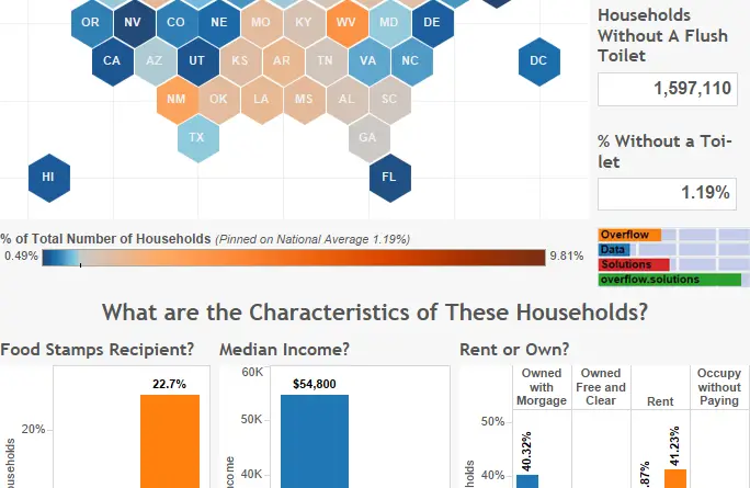
What % of american households don’t have a toilet?

1.19% of households in the U.S. don’t have a flush toilet.

Read more: What % of american households don’t have a toilet? →
Satellite imagesSpaceWeather
April 10, 2016 Alex

Italy at night

Italy at night from the International Space Station by astronaut Tim Peake.

Read more: Italy at night →
Nature
April 10, 2016 Alex

Distribution of the invasive Zebra and Quagga Mussels in U.S. waterways

Read more: Distribution of the invasive Zebra and Quagga Mussels in U.S. waterways →
Interactive mapsPolitical mapsReal estate
April 10, 2016 Alex

State of 2016 democratic presidental primaries (April 9)

Read more: State of 2016 democratic presidental primaries (April 9) →
Languages
April 10, 2016 Alex

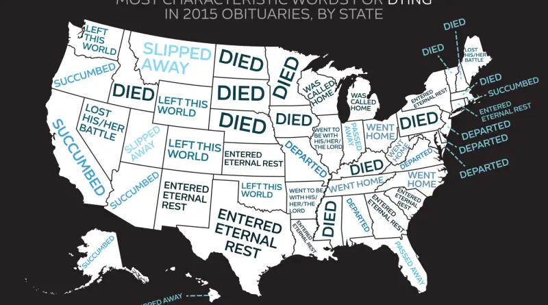
Most characteristic words for dying in 2015 obituaries, by state

“Passed away” was used in 32.5 percent of all obituaries and topped the national list. In every single state, it

Read more: Most characteristic words for dying in 2015 obituaries, by state →
BusinessHistorical MapsMapping StereotypesOld maps
April 10, 2016 Alex

Europe during the 15th century

Read more: Europe during the 15th century →
EducationInteractive mapsLawsMapping Health
April 10, 2016 Alex

Is smoking banned in schools

Read more: Is smoking banned in schools →
ChartsMapping Health
April 9, 2016 Alex

The unrelenting march of diabets

Diabetes is the world’s eighth biggest killer, accounting for some 1.5 million deaths each year. A major new World Health

Read more: The unrelenting march of diabets →
Economic mapsEthnic mapsInteractive mapsMapping Stereotypes
April 9, 2016 Alex

Economy Ranking by Country

An economy is an area of the production, distribution, or trade, and consumption of goods and services by different agents

Read more: Economy Ranking by Country →
CitiesEnvironment mapsInteractive mapsPollution
April 9, 2016 Alex

Where are L.A.’s dirtiest streets?

Inspectors gave failing cleanliness grades to more than 370 miles of streets and alleys in Los Angeles, or about 4%

Read more: Where are L.A.’s dirtiest streets? →
Dot mapsEnvironment mapsInternetNatural disastersSlider
April 9, 2016 Alex

USGS Earthquake Forecast Maps Now Include Human-Induced Earthquakes

For the first time, new USGS maps identify potential ground-shaking hazards from both human-induced and natural earthquakes. In the past,

Read more: USGS Earthquake Forecast Maps Now Include Human-Induced Earthquakes →
Page 312 of 521« First«...308309310311312313314315316...»Last »

Trending now

  • Soviet detailed map
    Detailed Cold War-era Soviet military map of the San Francisco Bay area (1980)Oct 22, 2017
  • World map of Y-DNA Haplogroups
    World map of Y-DNA HaplogroupsMay 17, 2017
  • World Map of the Most Uniquely Popular Word On Every County's Wikipedia Page
    The Most Uniquely Popular Word on Each Country’s Wikipedia Page MappedDec 1, 2022

Related Products

  • Push pin maps
  • Globe drinks cabinets
  • Maps of the United States
  • Board games
  • Monopoly
  • Map-based strategy board games
  • History Board Games
  • Coloring Books
  • Handheld GPS
  • GPS Watches
  • GPS Trackers

Vivid Maps Tools

  • Convert Latitude/Longitude
  • Elevation Finder
  • Distance Calculator
  • Kilometers to Miles Distance & Length Converter
  • Weight Converter
  • Volume Converter
  • Daylight Comparison
  • Time Zone Converter
  • Antipodes Map
  • Find cities with a similar climate
  • Find cities with a similar climate (2050)
  • How hot cities could be in 2050
  • The U.S. Population Lines

Stay connected

Get the latest maps, insights and updates delivered to your inbox.

Unsubscribe anytime.

VividMaps

Maps that explain the world.

Beautiful, data-rich maps to help you understand our world — its people, places and connections.

Explore

World map World atlas Map posters Globes

Company

About Privacy Contact

Stay connected

Follow us for the latest maps, insights and updates.

Independent WebsiteVirusScanner trust report for vividmaps.com
© 2026 Vivid Maps. All rights reserved.
A more connected world