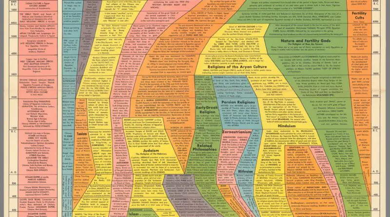
Skip to content
Vivid Maps Logo

  • Atlases
  • Map Posters
  • Scratch Maps
  • Globes
  • Videos
Global Coffee Arabica Cultivation Mapped
AgricultureNewsVivid maps

From Highland Peaks to Lowland Valleys: Mapping the World’s Coffee and Tea Territories

August 19, 2025 Alex
Mapped Wheat Maize and Rice production
AgricultureNewsVivid maps

Wheat, Maize, and Rice: Mapping the Crops That Feed the World

August 15, 2025 Alex
World map of countries based on share of immigrants
DemographyNewsVivid maps

Mapped: Countries With the Lowest Percentage of Immigrants

June 18, 2025 Alex
Global Coffee Arabica Cultivation Mapped
AgricultureNewsVivid maps

From Highland Peaks to Lowland Valleys: Mapping the World’s Coffee and Tea Territories

August 19, 2025 Alex
Mapped Wheat Maize and Rice production
AgricultureNewsVivid maps

Wheat, Maize, and Rice: Mapping the Crops That Feed the World

August 15, 2025 Alex
Mapped: Long-Term Orientation in World Cultures
Cultural cartography

Long-Term Orientation in World Cultures

August 10, 2025 Alex
Mapped: Which Countries Get the Most Paid Time Off Overall
Economic mapsJob

How Paid Vacation Varies Around the World

August 5, 2025 Alex
Map of happiest and unhappiest countries in the world
Economic mapsNewsPolitical mapsVivid maps
May 7, 2020 Alex

The happiest countries in the world (2013 – 2020)

Happiness connects with many life factors: GDP per capita, social support, healthy life expectancy, freedom to make life choices, generosity, and the absence of corruption. Which country is the happiest?

Read More
Monoethnic countries around the world Mapped
Ethnic maps
May 2, 2020 Alex

Monoethnic Countries Around the World

Monoethnic countries, where a single ethnic group comprises the majority of the population, offer a unique perspective on cultural homogeneity. The world map below shows monoethnic countries around the world – countries where +85% of the population belongs to one ethnicity.

Read More
Map of the Unions of British Isles
Political maps
April 26, 2020 Alex

Unions and Relationships in the British Isles Explained

The British Isles include the islands of Great Britain, Ireland, and more than 6,000 smaller isles, including the Isle of Man, the Bailiwicks of Jersey, and Guernsey. They comprise 315,159 sq km or 121,684 sq mi and collectively have almost 72 million people.

Read More
Tipping etiquette around the world
Economic mapsInfographicsTravel maps
April 15, 2020 Alex

Tipping etiquette around the world

Choosing whether or not to tip is the natural part; the real difficulty lies in determining how much to tip. Too little might be considered an offence. Too much and you could be viewed as vulgar or proud. In places like China and Japan, practically all tipping is seen as rude, and it’s just not done.

Read More
Map of distribution and expansion of olive trees over the Mediterranean Basin
AgricultureNature
April 7, 2020 Alex

Olive Tree in the Mediterranean Bassin

The olive is an evergreen small tree or shrub native to the Mediterranean Basin from the Middle East to Portugal. The olive has initially been planted 7,000 years ago in Mediterranean countries. Today about 867 million olive trees are on the planet, occupying approximately 9.7 million hectares.

Read More
Turning left at a red light in the United States and Canada mapped
Laws
April 5, 2020 Alex

Can You Turn Left on Red? A Map of Left-Turn-on-Red Laws in the United States and Canada

Left on red? It depends where you are. Our map shows the surprising differences in traffic laws across the U.S. and Canada — and why some places say yes while others say no.

Read More
The atlas of the United States in the style of Joy Division
NewsVivid maps
April 3, 2020 Alex

The atlas of the United States in the style of Joy Division

The maps of the United States show elevation, precipitation, and population density in the style of Joy Division.

Read More
COVID-19 pandemic
HealthNews
March 25, 2020 Alex

Coronavirus pandemic mapped

The coronavirus pandemic caused by severe acute respiratory syndrome (COVID-19) was first known in Wuhan (Chinese province Hube) in December 2019. It was identified as a pandemic by the World Health Organization on 11 March 2020.

Read More
Languages
March 18, 2020 Alex

Demonyms of the U.S. and Canada

A demonym is a word that names citizens of a specific place, generally obtained from the name of the area. Demonyms are used to name the overall population of a specific place, regardless of ethnicity, religion, language, or other cultural features.

Read More
Mapped: What percentage of the population lives in the Northern and Southern Hemispheres?
Demography
March 16, 2020 Alex

How much of the population lives in the Northern and Southern Hemispheres?

Approximately 87% of the world’s population lives in the Northern Hemisphere, while the remaining 13% resides in the Southern Hemisphere. This imbalance is primarily due to the larger landmass and more habitable regions in the Northern Hemisphere compared to the Southern Hemisphere. H

Read More
Page 60 of 673« First«...102030...5859606162...708090...»Last »

Trending now

  • The Price of Sex around the World Mapped
  • U.S. Presidential election 2024 (voter-margin + vote total) mapped
    Mapping America’s Rightward Shift: The 2024 Presidential Election County by County

Related Products

Push pin maps · Globe drinks cabinets · Maps of the United States · Board games · Monopoly · Map-based strategy board games · History Board Games · Coloring Books · Handheld GPS · GPS Watches · GPS Trackers

Vivid Maps Tools

· Convert Latitude/Longitude
· Elevation Finder
· Distance Calculator
· Kilometers to Miles Converter
· Kilograms to Pounds Converter
· Liters to Gallons Converter
· Temperature Converter
· Find cities with a similar climate
· Find cities with a similar climate (2050)
· How hot cities could be in 2050
· The U.S. Population Lines

About
Privacy Policy

Copyright © 2025 Vivid Maps. All rights reserved.