Skip to content
VividMaps

  • Atlases
  • Map Posters
  • Scratch Maps
  • Globes
  • Videos
HumorInternetMapping StereotypesMexico
May 12, 2017 Alex

Things that wouldn’t exist if Mexico hadn’t lost its territory

Image credits: Eduardo Salles

Read more: Things that wouldn’t exist if Mexico hadn’t lost its territory →

CitiesPollution
May 12, 2017 Alex

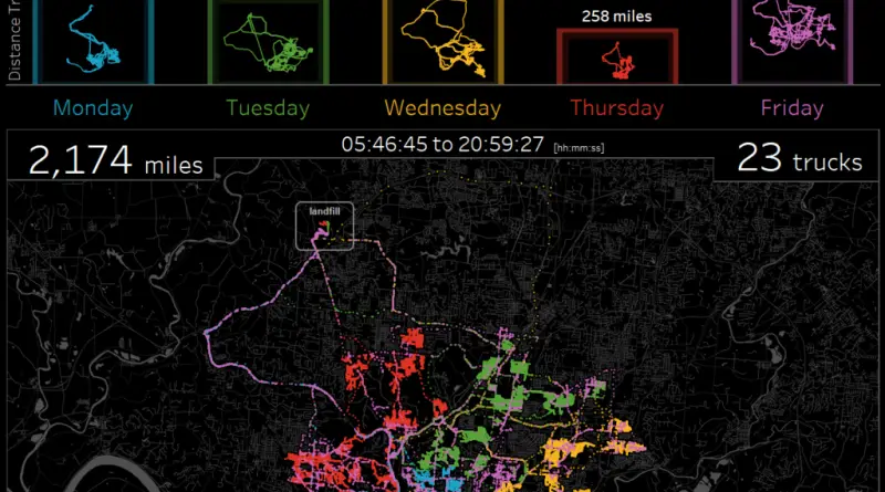
A week of trash routes in city of Cincinnati
Source: dataplusscience.com

Read more: A week of trash routes in city of Cincinnati →
Animated mapsCitiesClimate ChangePopulationVivid maps
May 12, 2017 Alex

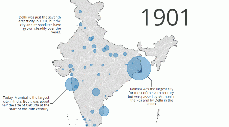
India’s 50 most populous cities (1901 – 2011)

Delhi passed Kolkata to become the second most populous city in the country, as population growth slowed in the latter

Read more: India’s 50 most populous cities (1901 – 2011) →
Animated mapsBusinessEnvironment maps
May 12, 2017 Alex

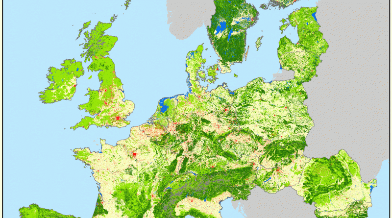
Europe gross land changes (1900 – 2010)

EU27CH – gross land changes processed by HILDA model (v2.0). Source: wur.nl

Read more: Europe gross land changes (1900 – 2010) →
Mapping Health
May 12, 2017 Alex

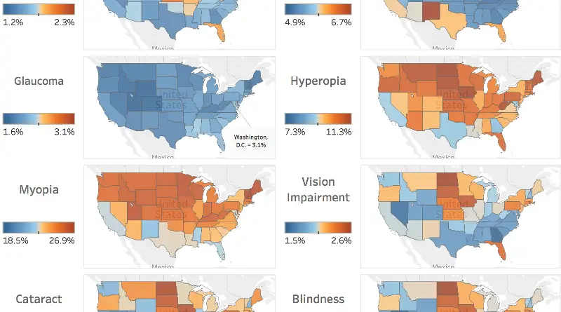
Vision problems prevalence in the United States

via vaultanalytics.com (data: visionproblemsus.org )

Read more: Vision problems prevalence in the United States →
Ethnic mapsInteractive maps
May 11, 2017 Alex

Average commute time to work in the United States

The average travel time to work in the United States is 25.4 minutes, according to the U.S. Census Bureau. Move

Read more: Average commute time to work in the United States →
ClimateMapping Stereotypes
May 11, 2017 Alex

Number of days with snow on ground (September 2016 – April 2017)

NASA

Read more: Number of days with snow on ground (September 2016 – April 2017) →
FoodInfographics
May 11, 2017 Alex

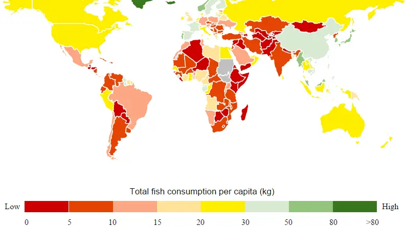
Total fish consumption per capita

Source: 2openlab.it

Read more: Total fish consumption per capita →
CitiesMapping StereotypesNatureTravelWorld
May 11, 2017 Alex

A global map of Accessibility

Travel time to major cities (in hours & days) and shipping lane density. Facts: – Only 10% of the land

Read more: A global map of Accessibility →
News
May 11, 2017 Alex

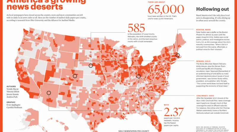
The Silent Spread: How News Deserts Are Reshaping America’s Media Landscape

An in-depth look at the changing landscape of local news across America, featuring comprehensive maps that illustrate where daily newspapers are disappearing and how media ownership is becoming increasingly concentrated.

Read more: The Silent Spread: How News Deserts Are Reshaping America’s Media Landscape →
World
May 11, 2017 Alex

Different levels of workplace protections in the United States for the LGBTQ community

Reddit user: Yourdadgivesgoodhead

Read more: Different levels of workplace protections in the United States for the LGBTQ community →
CartogramsMigration maps
May 11, 2017 Alex

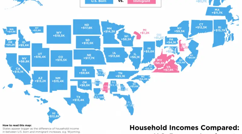
Differences in household income, U.S. born vs Immigrants

States appear bigger as the difference of households income in between U.S. born and immigrant increases, e.g. Wyoming (+$17,8K). Conversely,

Read more: Differences in household income, U.S. born vs Immigrants →
Political maps
May 10, 2017 Alex

Political affiliation of the heads of state & government in the European council (1961 – 2017)

Reddit user: Bezbojnicul

Read more: Political affiliation of the heads of state & government in the European council (1961 – 2017) →
Page 155 of 521« First«...151152153154155156157158159...»Last »

Trending now

  • Soviet detailed map
    Detailed Cold War-era Soviet military map of the San Francisco Bay area (1980)Oct 22, 2017
  • Human races of the 19th century
    How Has Our View of Human Diversity Changed Since the 19th Century?Oct 22, 2017
  • World map of Y-DNA Haplogroups
    World map of Y-DNA HaplogroupsMay 17, 2017

Related Products

  • Push pin maps
  • Globe drinks cabinets
  • Maps of the United States
  • Board games
  • Monopoly
  • Map-based strategy board games
  • History Board Games
  • Coloring Books
  • Handheld GPS
  • GPS Watches
  • GPS Trackers

Vivid Maps Tools

  • Convert Latitude/Longitude
  • Elevation Finder
  • Distance Calculator
  • Kilometers to Miles Distance & Length Converter
  • Weight Converter
  • Volume Converter
  • Daylight Comparison
  • Time Zone Converter
  • Antipodes Map
  • Find cities with a similar climate
  • Find cities with a similar climate (2050)
  • How hot cities could be in 2050
  • The U.S. Population Lines

Stay connected

Get the latest maps, insights and updates delivered to your inbox.

Unsubscribe anytime.

VividMaps

Maps that explain the world.

Beautiful, data-rich maps to help you understand our world — its people, places and connections.

Explore

World map World atlas Map posters Globes

Company

About Privacy Contact

Stay connected

Follow us for the latest maps, insights and updates.

Independent WebsiteVirusScanner trust report for vividmaps.com
© 2026 Vivid Maps. All rights reserved.
A more connected world