Skip to content
VividMaps

  • Atlases
  • Map Posters
  • Scratch Maps
  • Globes
  • Videos
Interactive mapsMapping StereotypesPolitical maps
February 13, 2016 Alex

Good Country Index

The Good Country Index measures how much each of the 125 countries on the list contribute to the planet and

Read more: Good Country Index →

CitiesSatellite MapsSlider
February 13, 2016 Alex

Satellite Bird’s Eye View of San Francisco

This is an incredible hi-res bird’s eye view of San Francisco taken by DigitalGlobe’s WorldView-3 satellite. WorldView-3 is about 17°

Read more: Satellite Bird’s Eye View of San Francisco →
Animated chartsChartsDemographyForecastsMapping StereotypesPopulation
February 13, 2016 Alex

Population structure of Poland during the 1960-2060 period

Related posts: – Population structure of Sweden during the 1960-2060 period – Population structure of Spain during the 1960-2060 period

Read more: Population structure of Poland during the 1960-2060 period →
Animated chartsChartsDemographyEnvironment mapsForecastsLawsMapping StereotypesPollutionPopulation
February 13, 2016 Alex

Population structure of Sweden during the 1960-2060 period

Related posts: – Population structure of Spain during the 1960-2060 period  – Population structure of Turkey during the 1960-2060 period

Read more: Population structure of Sweden during the 1960-2060 period →
Economic mapsInteractive mapsWorld
February 13, 2016 Alex

Percent of Working-Age Population

Read more: Percent of Working-Age Population →
Economic mapsMapping Stereotypes
February 13, 2016 Alex

Unemployment rate by U.S. county (2007 – 2014)

Read more: Unemployment rate by U.S. county (2007 – 2014) →
AgricultureEnvironment maps
February 13, 2016 Alex

Cattle density by U.S. coutny

Read more: Cattle density by U.S. coutny →
AgricultureInteractive mapsPolitical mapsSlider
February 13, 2016 Alex

Election outcome in counties with more cattle than people

Read more: Election outcome in counties with more cattle than people →
Real estate
February 13, 2016 Alex

% of housing units used for Recreational/Seasonal purposes by US Zip Code

Read more: % of housing units used for Recreational/Seasonal purposes by US Zip Code →
Economic mapsSlider
February 13, 2016 Alex

How much does your state spend on Valentine’s Day gifts?

A new study from Finder.com surveyed more than 3,000 people across the country, and asked them how much they planned

Read more: How much does your state spend on Valentine’s Day gifts? →
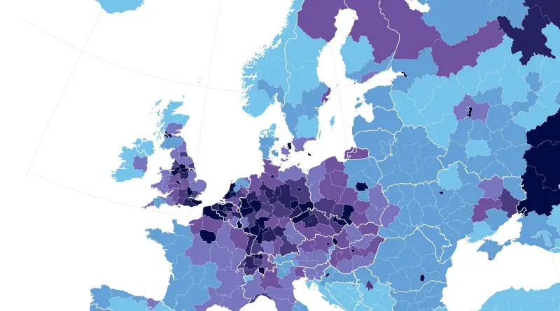
Railroads in Europe
Transport
February 13, 2016 Alex

European Rail Maps

A look at the railway infrastructure in Europe shows around 250,000 kilometers of tracks across the entire continent, just slightly lower than the United States’ length of ways.

Read more: European Rail Maps →
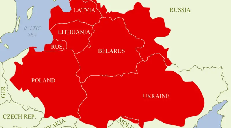
Polish Lithuanian Commonwealth vs Modern countries mapped
Historical Maps
February 12, 2016 Alex

The Incredible Shrinking Empire: How Poland’s Territory Changed Over 400 Years

Explore the dramatic territorial evolution of Poland – from ruling vast lands across Eastern Europe to disappearing entirely, and finally emerging as today’s modern nation.

Read more: The Incredible Shrinking Empire: How Poland’s Territory Changed Over 400 Years →
DemographyEthnic mapsPopulationVivid maps
February 12, 2016 Alex

U.S. Hispanic population, percent increase by county

Related posts: – U.S. Hispanic Population under 5 years of age Percent Change by County (2010 – 2014) – U.S.

Read more: U.S. Hispanic population, percent increase by county →
Page 341 of 521« First«...337338339340341342343344345...»Last »

Trending now

  • Soviet detailed map
    Detailed Cold War-era Soviet military map of the San Francisco Bay area (1980)Oct 22, 2017
  • World map of Y-DNA Haplogroups
    World map of Y-DNA HaplogroupsMay 17, 2017
  • Maps of differences between East and West Germany
    Germany is still divided by east and westSep 11, 2020

Related Products

  • Push pin maps
  • Globe drinks cabinets
  • Maps of the United States
  • Board games
  • Monopoly
  • Map-based strategy board games
  • History Board Games
  • Coloring Books
  • Handheld GPS
  • GPS Watches
  • GPS Trackers

Vivid Maps Tools

  • Convert Latitude/Longitude
  • Elevation Finder
  • Distance Calculator
  • Kilometers to Miles Distance & Length Converter
  • Weight Converter
  • Volume Converter
  • Daylight Comparison
  • Time Zone Converter
  • Antipodes Map
  • Find cities with a similar climate
  • Find cities with a similar climate (2050)
  • How hot cities could be in 2050
  • The U.S. Population Lines

Stay connected

Get the latest maps, insights and updates delivered to your inbox.

Unsubscribe anytime.

VividMaps

Maps that explain the world.

Beautiful, data-rich maps to help you understand our world — its people, places and connections.

Explore

World map World atlas Map posters Globes

Company

About Privacy Contact

Stay connected

Follow us for the latest maps, insights and updates.

Independent WebsiteVirusScanner trust report for vividmaps.com
© 2026 Vivid Maps. All rights reserved.
A more connected world